

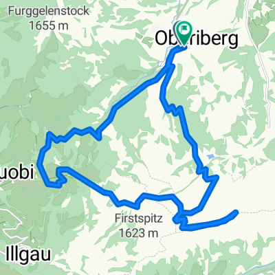
Weisstannen-Bränten
A cycling route starting in Unteriberg, Canton of Schwyz, Switzerland.
Overview
About this route
Beautiful round trip with lots of views!
- -:--
- Duration
- 43.7 km
- Distance
- 1,182 m
- Ascent
- 1,179 m
- Descent
- ---
- Avg. speed
- ---
- Max. altitude
Continue with Bikemap
Use, edit, or download this cycling route
You would like to ride Weisstannen-Bränten or customize it for your own trip? Here is what you can do with this Bikemap route:
Free features
- Save this route as favorite or in collections
- Copy & plan your own version of this route
- Sync your route with Garmin or Wahoo
Premium features
Free trial for 3 days, or one-time payment. More about Bikemap Premium.
- Navigate this route on iOS & Android
- Export a GPX / KML file of this route
- Create your custom printout (try it for free)
- Download this route for offline navigation
Discover more Premium features.
Get Bikemap PremiumFrom our community
Other popular routes starting in Unteriberg
 Weisstannen-Bränten
- Distance
- 43.7 km
- Ascent
- 1,182 m
- Descent
- 1,179 m
- Location
- Unteriberg, Canton of Schwyz, Switzerland
 Unteriberg - Sisikon 2
- Distance
- 32 km
- Ascent
- 991 m
- Descent
- 1,460 m
- Location
- Unteriberg, Canton of Schwyz, Switzerland
 SoE1B Unteriberg-Biberbrugg-Sattel
- Distance
- 28.9 km
- Ascent
- 229 m
- Descent
- 338 m
- Location
- Unteriberg, Canton of Schwyz, Switzerland
 Klöntalersee-Klausenpass-Altdorf
- Distance
- 79.9 km
- Ascent
- 2,694 m
- Descent
- 3,349 m
- Location
- Unteriberg, Canton of Schwyz, Switzerland
 Sihlsee-Villigen
- Distance
- 81.7 km
- Ascent
- 342 m
- Descent
- 862 m
- Location
- Unteriberg, Canton of Schwyz, Switzerland
 Pomysl 1 - Hoch Ybrig
- Distance
- 23.3 km
- Ascent
- 933 m
- Descent
- 927 m
- Location
- Unteriberg, Canton of Schwyz, Switzerland
 myhten
- Distance
- 57 km
- Ascent
- 492 m
- Descent
- 694 m
- Location
- Unteriberg, Canton of Schwyz, Switzerland
 Ausfahrt von Studen SZ nach Willerzell
- Distance
- 10.8 km
- Ascent
- 324 m
- Descent
- 298 m
- Location
- Unteriberg, Canton of Schwyz, Switzerland
Open it in the app