

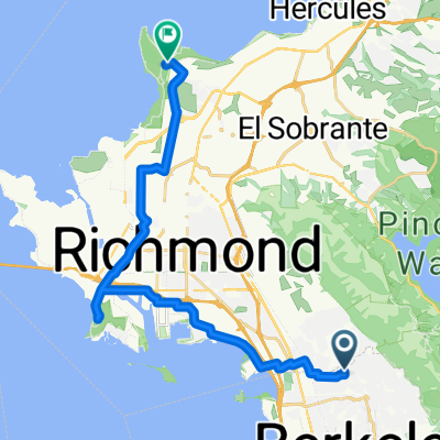
WildCat_Bear1
A cycling route starting in Kensington, California, United States.
Overview
About this route
Easy Level. Good Climb
- -:--
- Duration
- 17.3 km
- Distance
- 403 m
- Ascent
- 505 m
- Descent
- ---
- Avg. speed
- ---
- Max. altitude

Route quality
Waytypes & surfaces along the route
Waytypes
Road
17.2 km
(99 %)
Access road
0.1 km
(<1 %)
Surfaces
Paved
16.5 km
(95 %)
Asphalt
15.3 km
(89 %)
Paved (undefined)
1.2 km
(7 %)
Undefined
0.8 km
(5 %)
Continue with Bikemap
Use, edit, or download this cycling route
You would like to ride WildCat_Bear1 or customize it for your own trip? Here is what you can do with this Bikemap route:
Free features
- Save this route as favorite or in collections
- Copy & plan your own version of this route
- Sync your route with Garmin or Wahoo
Premium features
Free trial for 3 days, or one-time payment. More about Bikemap Premium.
- Navigate this route on iOS & Android
- Export a GPX / KML file of this route
- Create your custom printout (try it for free)
- Download this route for offline navigation
Discover more Premium features.
Get Bikemap PremiumFrom our community
Other popular routes starting in Kensington
 Southern Bay Trail
- Distance
- 291.4 km
- Ascent
- 129 m
- Descent
- 173 m
- Location
- Kensington, California, United States
 200–214 Ashbury Ave, El Cerrito to 1136 Washington Ave, Albany
- Distance
- 10.9 km
- Ascent
- 220 m
- Descent
- 223 m
- Location
- Kensington, California, United States
 Berkeley to Giant Highway 5551, Richmond
- Distance
- 24.8 km
- Ascent
- 189 m
- Descent
- 272 m
- Location
- Kensington, California, United States
 WildCat_Bear1
- Distance
- 17.3 km
- Ascent
- 403 m
- Descent
- 505 m
- Location
- Kensington, California, United States
 Death Ride: Training Ride 1
- Distance
- 25 km
- Ascent
- 485 m
- Descent
- 598 m
- Location
- Kensington, California, United States
 Nimitz
- Distance
- 1 km
- Ascent
- 19 m
- Descent
- 43 m
- Location
- Kensington, California, United States
 The Alameda 576, Berkeley to East 14th Street 1200, San Leandro
- Distance
- 29.8 km
- Ascent
- 148 m
- Descent
- 226 m
- Location
- Kensington, California, United States
 555 Santa Barbara Rd, Berkeley to 31–99 Somerset Pl, Berkeley
- Distance
- 1.3 km
- Ascent
- 16 m
- Descent
- 74 m
- Location
- Kensington, California, United States
Open it in the app