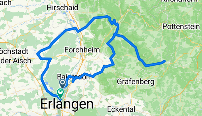
Obertrubach-Feuerstein-Adelsdorf
A cycling route starting in Möhrendorf, Bavaria, Germany.
Overview
About this route
2 + Intervall flach
1 + Intervall Berg- -:--
- Duration
- 115.6 km
- Distance
- 588 m
- Ascent
- 588 m
- Descent
- ---
- Avg. speed
- ---
- Avg. speed
Route quality
Waytypes & surfaces along the route
Waytypes
Busy road
75.1 km
(65 %)
Road
31.1 km
(27 %)
Surfaces
Paved
113.2 km
(98 %)
Unpaved
0.3 km
(<1 %)
Asphalt
112.4 km
(97 %)
Paved (undefined)
0.7 km
(<1 %)
Continue with Bikemap
Use, edit, or download this cycling route
You would like to ride Obertrubach-Feuerstein-Adelsdorf or customize it for your own trip? Here is what you can do with this Bikemap route:
Free features
- Save this route as favorite or in collections
- Copy & plan your own version of this route
- Sync your route with Garmin or Wahoo
Premium features
Free trial for 3 days, or one-time payment. More about Bikemap Premium.
- Navigate this route on iOS & Android
- Export a GPX / KML file of this route
- Create your custom printout (try it for free)
- Download this route for offline navigation
Discover more Premium features.
Get Bikemap PremiumFrom our community
Other popular routes starting in Möhrendorf
- Möhrendorf-Adlitz-Runde
- Distance
- 19.9 km
- Ascent
- 144 m
- Descent
- 148 m
- Location
- Möhrendorf, Bavaria, Germany
- Möhrendorf, Hetzleser-Berg über Regensberg wieder zurük
- Distance
- 44.8 km
- Ascent
- 496 m
- Descent
- 496 m
- Location
- Möhrendorf, Bavaria, Germany
- Dammweiher
- Distance
- 9.4 km
- Ascent
- 74 m
- Descent
- 75 m
- Location
- Möhrendorf, Bavaria, Germany
- 2023-05-28 RR Sonntagstour
- Distance
- 105.9 km
- Ascent
- 423 m
- Descent
- 415 m
- Location
- Möhrendorf, Bavaria, Germany
- 2019-01-03 Masters Light
- Distance
- 82.2 km
- Ascent
- 363 m
- Descent
- 366 m
- Location
- Möhrendorf, Bavaria, Germany
- kleine runde
- Distance
- 21.9 km
- Ascent
- 116 m
- Descent
- 116 m
- Location
- Möhrendorf, Bavaria, Germany
- Erlanger Triathlon - 2010 - Radstrecke 40km
- Distance
- 39.3 km
- Ascent
- 228 m
- Descent
- 228 m
- Location
- Möhrendorf, Bavaria, Germany
- 21.05.2009_Vatertagstour
- Distance
- 119 km
- Ascent
- 1,188 m
- Descent
- 1,193 m
- Location
- Möhrendorf, Bavaria, Germany
Open it in the app