

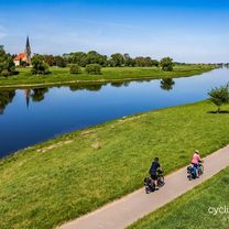
Rehbocktal
A cycling route starting in Dresden, Saxony, Germany.
Overview
About this route
Starting and ending point: Gorbitzcenter
Transport connection: Tram lines 2, 7 stops Kirschenstraße or Schlehenstraße
Route length: approx. 45 km
Generally little-frequented side streets and asphalted bike paths
Short sections on the federal road B6 towards Meißen cannot be avoided due to the incomplete Elbe bike path.
In the Rehbock Valley, partially paved hiking trail, in the section towards Batzdorf Castle very steep and due to the paving a short 'bike hike' (approx. 200 m).
- -:--
- Duration
- 44.1 km
- Distance
- 405 m
- Ascent
- 405 m
- Descent
- ---
- Avg. speed
- ---
- Max. altitude
Continue with Bikemap
Use, edit, or download this cycling route
You would like to ride Rehbocktal or customize it for your own trip? Here is what you can do with this Bikemap route:
Free features
- Save this route as favorite or in collections
- Copy & plan your own version of this route
- Sync your route with Garmin or Wahoo
Premium features
Free trial for 3 days, or one-time payment. More about Bikemap Premium.
- Navigate this route on iOS & Android
- Export a GPX / KML file of this route
- Create your custom printout (try it for free)
- Download this route for offline navigation
Discover more Premium features.
Get Bikemap PremiumFrom our community
Other popular routes starting in Dresden
 Nachtcruise DLC 14
- Distance
- 16.8 km
- Ascent
- 64 m
- Descent
- 59 m
- Location
- Dresden, Saxony, Germany
 Elbe Cycle Route - Dresden to Magdeburg
- Distance
- 312.5 km
- Ascent
- 538 m
- Descent
- 597 m
- Location
- Dresden, Saxony, Germany
 In den Norden- 60er
- Distance
- 59.7 km
- Ascent
- 316 m
- Descent
- 319 m
- Location
- Dresden, Saxony, Germany
 Elbe-Runde_2
- Distance
- 27.2 km
- Ascent
- 78 m
- Descent
- 78 m
- Location
- Dresden, Saxony, Germany
 Rehbocktal
- Distance
- 44.1 km
- Ascent
- 405 m
- Descent
- 405 m
- Location
- Dresden, Saxony, Germany
 Dresden - Berlin Zehlendorf
- Distance
- 205.9 km
- Ascent
- 367 m
- Descent
- 440 m
- Location
- Dresden, Saxony, Germany
 rechts und linkselbische Taeler
- Distance
- 59.5 km
- Ascent
- 677 m
- Descent
- 673 m
- Location
- Dresden, Saxony, Germany
 Stoppomat, Landberg & Klingenberg
- Distance
- 74.7 km
- Ascent
- 477 m
- Descent
- 478 m
- Location
- Dresden, Saxony, Germany
Open it in the app