

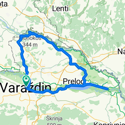
Kajkavijana 2013
A cycling route starting in Varaždin, Varaždin County, Croatia.
Overview
About this route
Everything is known....
- -:--
- Duration
- 239.5 km
- Distance
- 3,362 m
- Ascent
- 3,364 m
- Descent
- ---
- Avg. speed
- ---
- Max. altitude

Continue with Bikemap
Use, edit, or download this cycling route
You would like to ride Kajkavijana 2013 or customize it for your own trip? Here is what you can do with this Bikemap route:
Free features
- Save this route as favorite or in collections
- Copy & plan your own version of this route
- Split it into stages to create a multi-day tour
- Sync your route with Garmin or Wahoo
Premium features
Free trial for 3 days, or one-time payment. More about Bikemap Premium.
- Navigate this route on iOS & Android
- Export a GPX / KML file of this route
- Create your custom printout (try it for free)
- Download this route for offline navigation
Discover more Premium features.
Get Bikemap PremiumFrom our community
Other popular routes starting in Varaždin
 sračinec-vž toplice
- Distance
- 53.7 km
- Ascent
- 1,103 m
- Descent
- 1,122 m
- Location
- Varaždin, Varaždin County, Croatia
 Vž-Mandre(Pisarovina, Vuk.Cerovac, Ondić, Gračac, Posedarje)
- Distance
- 395.8 km
- Ascent
- 1,589 m
- Descent
- 1,765 m
- Location
- Varaždin, Varaždin County, Croatia
 Miroslava Krleže - Zagrebačka 57
- Distance
- 28.1 km
- Ascent
- 30 m
- Descent
- 31 m
- Location
- Varaždin, Varaždin County, Croatia
 179. Varaždinski maraton
- Distance
- 41.4 km
- Ascent
- 57 m
- Descent
- 54 m
- Location
- Varaždin, Varaždin County, Croatia
 Kajkavijana 2013
- Distance
- 239.5 km
- Ascent
- 3,362 m
- Descent
- 3,364 m
- Location
- Varaždin, Varaždin County, Croatia
 De Trg Matije Gupca à Trg Matije Gupca
- Distance
- 132.7 km
- Ascent
- 250 m
- Descent
- 249 m
- Location
- Varaždin, Varaždin County, Croatia
 Hallerova aleja 5, Varaždin to Koprivnička ulica 6, Varaždin
- Distance
- 3.8 km
- Ascent
- 9 m
- Descent
- 17 m
- Location
- Varaždin, Varaždin County, Croatia
 Ulica Tome Masaryka 3, Varaždin to Ulica Franje Račkog 36, Varaždin
- Distance
- 29.2 km
- Ascent
- 97 m
- Descent
- 99 m
- Location
- Varaždin, Varaždin County, Croatia
Open it in the app