

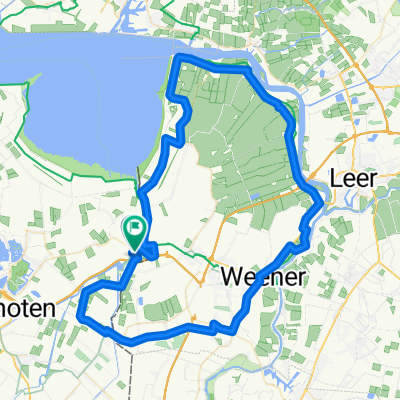
Am Dollard
A cycling route starting in Bunde, Lower Saxony, Germany.
Overview
About this route
The more you write here, the more helpful it is for other users.
Open stretch, the direction of travel should be coordinated with the wind direction.
In winter, poorly lit. Mobile phone recommended, as it's a lonely stretch, outside normal road traffic!!
- -:--
- Duration
- 44.6 km
- Distance
- 5 m
- Ascent
- 7 m
- Descent
- ---
- Avg. speed
- ---
- Max. altitude
Route quality
Waytypes & surfaces along the route
Waytypes
Quiet road
20.1 km
(45 %)
Track
7.6 km
(17 %)
Surfaces
Paved
35.7 km
(80 %)
Unpaved
0.4 km
(1 %)
Asphalt
25 km
(56 %)
Concrete
9.8 km
(22 %)
Continue with Bikemap
Use, edit, or download this cycling route
You would like to ride Am Dollard or customize it for your own trip? Here is what you can do with this Bikemap route:
Free features
- Save this route as favorite or in collections
- Copy & plan your own version of this route
- Sync your route with Garmin or Wahoo
Premium features
Free trial for 3 days, or one-time payment. More about Bikemap Premium.
- Navigate this route on iOS & Android
- Export a GPX / KML file of this route
- Create your custom printout (try it for free)
- Download this route for offline navigation
Discover more Premium features.
Get Bikemap PremiumFrom our community
Other popular routes starting in Bunde
 rondje Duitsland
- Distance
- 91.5 km
- Ascent
- 24 m
- Descent
- 23 m
- Location
- Bunde, Lower Saxony, Germany
 north sea cycle route deutscher Teil
- Distance
- 180.9 km
- Ascent
- 0 m
- Descent
- 0 m
- Location
- Bunde, Lower Saxony, Germany
 rondje Ditzum
- Distance
- 76.7 km
- Ascent
- 10 m
- Descent
- 9 m
- Location
- Bunde, Lower Saxony, Germany
 Erkundung
- Distance
- 61.6 km
- Ascent
- 14 m
- Descent
- 14 m
- Location
- Bunde, Lower Saxony, Germany
 Grosser Rheiderland Rundkurs
- Distance
- 83.5 km
- Ascent
- 19 m
- Descent
- 18 m
- Location
- Bunde, Lower Saxony, Germany
 Grensfietsen.NL - Etappe 1 (Groningen) - B-route - Grensfietsen.NL - Etappe 1 (Groningen) - B-route
- Distance
- 90.3 km
- Ascent
- 15 m
- Descent
- 9 m
- Location
- Bunde, Lower Saxony, Germany
 Bad Nieuweschans - Eemsdelta
- Distance
- 34.1 km
- Ascent
- 8 m
- Descent
- 8 m
- Location
- Bunde, Lower Saxony, Germany
 Bad Nieuweschans to Brassel
- Distance
- 47.8 km
- Ascent
- 19 m
- Descent
- 18 m
- Location
- Bunde, Lower Saxony, Germany
Open it in the app