

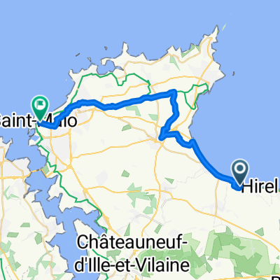
1-Hirel - Saint-Malo
A cycling route starting in Hirel, Brittany Region, France.
Overview
About this route
Hirel - Cancale - Saint-Malo
- -:--
- Duration
- 31.5 km
- Distance
- 186 m
- Ascent
- 158 m
- Descent
- ---
- Avg. speed
- ---
- Max. altitude
Route quality
Waytypes & surfaces along the route
Waytypes
Quiet road
4.1 km
(13 %)
Road
2.2 km
(7 %)
Surfaces
Paved
23.3 km
(74 %)
Unpaved
1.6 km
(5 %)
Asphalt
23.3 km
(74 %)
Loose gravel
1.3 km
(4 %)
Continue with Bikemap
Use, edit, or download this cycling route
You would like to ride 1-Hirel - Saint-Malo or customize it for your own trip? Here is what you can do with this Bikemap route:
Free features
- Save this route as favorite or in collections
- Copy & plan your own version of this route
- Sync your route with Garmin or Wahoo
Premium features
Free trial for 3 days, or one-time payment. More about Bikemap Premium.
- Navigate this route on iOS & Android
- Export a GPX / KML file of this route
- Create your custom printout (try it for free)
- Download this route for offline navigation
Discover more Premium features.
Get Bikemap PremiumFrom our community
Other popular routes starting in Hirel
 13 Le Fédeuil, Hirel à Dol-de-Bretagne
- Distance
- 5.6 km
- Ascent
- 18 m
- Descent
- 4 m
- Location
- Hirel, Brittany Region, France
 Hirel nach Avenue Louis Martin, Saint-Malo
- Distance
- 24.4 km
- Ascent
- 88 m
- Descent
- 89 m
- Location
- Hirel, Brittany Region, France
 Rue du Bord de Mer, Le Vivier-sur-Mer à Grande Randonnée Deux - au Fil de la Seine, Le Mont-Saint-Michel
- Distance
- 29.9 km
- Ascent
- 26 m
- Descent
- 26 m
- Location
- Hirel, Brittany Region, France
 8C Les Gasniers, Hirel à D 78, Hirel
- Distance
- 0.7 km
- Ascent
- 0 m
- Descent
- 0 m
- Location
- Hirel, Brittany Region, France
 1-Hirel - Saint-Malo
- Distance
- 31.5 km
- Ascent
- 186 m
- Descent
- 158 m
- Location
- Hirel, Brittany Region, France
 2 La Bruyère, Hirel à 66 Rue de Dol, La Fresnais
- Distance
- 1.1 km
- Ascent
- 0 m
- Descent
- 0 m
- Location
- Hirel, Brittany Region, France
 F05c inkorting via Tour de Manche
- Distance
- 8.5 km
- Ascent
- 15 m
- Descent
- 14 m
- Location
- Hirel, Brittany Region, France
 De 5–17 Rue du Bord de Mer, Hirel à 19–33 Rue Yves Estève, Dol-de-Bretagne
- Distance
- 8.7 km
- Ascent
- 0 m
- Descent
- 10 m
- Location
- Hirel, Brittany Region, France
Open it in the app