
HügelTourErzgebirge
A cycling route starting in Wolkenstein, Saxony, Germany.
Overview
About this route
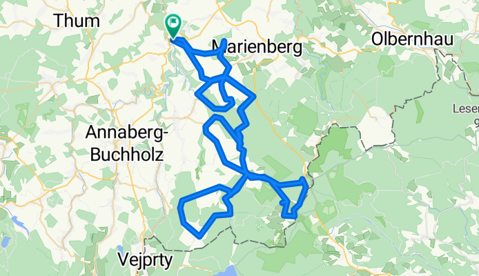
Wolkenstein, Brüder Höhe up, Großrückerswalde down, Schmiedeberg up, Eisenstraße down, Niederschmiedeberg, Arnsfeld up, Steinbach, Jöhstadt up, Grumbach down, Steinbach, Hirtstein up, Satzung, Reitzenhain, Steinbach down, Eisenstraße up, Großrückerswalde down, Wolkensteinerstraße to Wolkenstein.
- -:--
- Duration
- 92.7 km
- Distance
- 1,430 m
- Ascent
- 1,433 m
- Descent
- ---
- Avg. speed
- ---
- Max. altitude
Route quality
Waytypes & surfaces along the route
Waytypes
Road
45.4 km
(49 %)
Quiet road
13 km
(14 %)
Surfaces
Paved
59.3 km
(64 %)
Asphalt
59.3 km
(64 %)
Undefined
33.4 km
(36 %)
Continue with Bikemap
Use, edit, or download this cycling route
You would like to ride HügelTourErzgebirge or customize it for your own trip? Here is what you can do with this Bikemap route:
Free features
- Save this route as favorite or in collections
- Copy & plan your own version of this route
- Split it into stages to create a multi-day tour
- Sync your route with Garmin or Wahoo
Premium features
Free trial for 3 days, or one-time payment. More about Bikemap Premium.
- Navigate this route on iOS & Android
- Export a GPX / KML file of this route
- Create your custom printout (try it for free)
- Download this route for offline navigation
Discover more Premium features.
Get Bikemap PremiumFrom our community
Other popular routes starting in Wolkenstein
 Gemeindewanderung
- Distance
- 10.7 km
- Ascent
- 316 m
- Descent
- 314 m
- Location
- Wolkenstein, Saxony, Germany
 pressnitz - pockau
- Distance
- 54 km
- Ascent
- 594 m
- Descent
- 602 m
- Location
- Wolkenstein, Saxony, Germany
 Schönbrunn-Christophhammer-Weipert-Schönbr.
- Distance
- 63.4 km
- Ascent
- 584 m
- Descent
- 584 m
- Location
- Wolkenstein, Saxony, Germany
 Schönbrunn-Keilberg
- Distance
- 44.1 km
- Ascent
- 969 m
- Descent
- 169 m
- Location
- Wolkenstein, Saxony, Germany
 Wolkenstein - CZ - Fichtelberg - Chemnitz
- Distance
- 144.1 km
- Ascent
- 1,153 m
- Descent
- 1,224 m
- Location
- Wolkenstein, Saxony, Germany
 HügelTourErzgebirge
- Distance
- 92.7 km
- Ascent
- 1,430 m
- Descent
- 1,433 m
- Location
- Wolkenstein, Saxony, Germany
 Wolk-Eisenstr-Pock-Olb-Satz-Steinbach-Wolk
- Distance
- 97 km
- Ascent
- 939 m
- Descent
- 933 m
- Location
- Wolkenstein, Saxony, Germany
 Gehringswalde - Kühnhaide - Pockau
- Distance
- 39.8 km
- Ascent
- 455 m
- Descent
- 539 m
- Location
- Wolkenstein, Saxony, Germany
Open it in the app