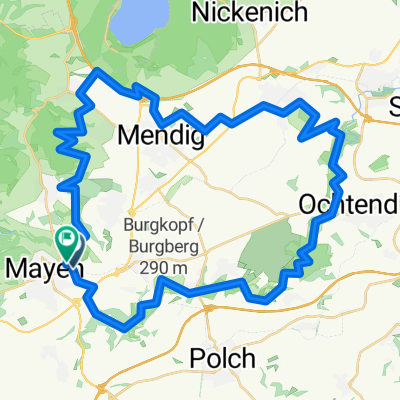
test#
A cycling route starting in Mayen, Rhineland-Palatinate, Germany.
Overview
About this route
khg
- -:--
- Duration
- 85.3 km
- Distance
- 759 m
- Ascent
- 831 m
- Descent
- ---
- Avg. speed
- ---
- Max. altitude
Route quality
Waytypes & surfaces along the route
Waytypes
Road
20.5 km
(24 %)
Track
8.5 km
(10 %)
Surfaces
Paved
53.8 km
(63 %)
Unpaved
5.1 km
(6 %)
Asphalt
52.1 km
(61 %)
Unpaved (undefined)
2.6 km
(3 %)
Continue with Bikemap
Use, edit, or download this cycling route
You would like to ride test# or customize it for your own trip? Here is what you can do with this Bikemap route:
Free features
- Save this route as favorite or in collections
- Copy & plan your own version of this route
- Split it into stages to create a multi-day tour
- Sync your route with Garmin or Wahoo
Premium features
Free trial for 3 days, or one-time payment. More about Bikemap Premium.
- Navigate this route on iOS & Android
- Export a GPX / KML file of this route
- Create your custom printout (try it for free)
- Download this route for offline navigation
Discover more Premium features.
Get Bikemap PremiumFrom our community
Other popular routes starting in Mayen
- Mayen -> via Eiterbachtal -> Virneburg -> via B258 -> Mayen
- Distance
- 34.6 km
- Ascent
- 691 m
- Descent
- 691 m
- Location
- Mayen, Rhineland-Palatinate, Germany
- Rundkurs Mayen - Polch -Mayen via Pluns
- Distance
- 21.2 km
- Ascent
- 324 m
- Descent
- 344 m
- Location
- Mayen, Rhineland-Palatinate, Germany
- int. Eifellandrundfahrt 2012 - RTF des Radsportclub Eifelland Mayen e.V. - 50 km Strecke
- Distance
- 46.2 km
- Ascent
- 608 m
- Descent
- 605 m
- Location
- Mayen, Rhineland-Palatinate, Germany
- int. Eifellandrundfahrt 2012 - RTF des Radsportclub Eifelland Mayen e.V. - 75 km Strecke
- Distance
- 74 km
- Ascent
- 773 m
- Descent
- 773 m
- Location
- Mayen, Rhineland-Palatinate, Germany
- 27.6.2010 Mayen Bad Godesberg
- Distance
- 81.4 km
- Ascent
- 588 m
- Descent
- 757 m
- Location
- Mayen, Rhineland-Palatinate, Germany
- In der Weiersbach 3, Mayen nach In der Weiersbach 1, Mayen
- Distance
- 5.7 km
- Ascent
- 273 m
- Descent
- 338 m
- Location
- Mayen, Rhineland-Palatinate, Germany
- Kleine Runde am Abend
- Distance
- 15.9 km
- Ascent
- 290 m
- Descent
- 325 m
- Location
- Mayen, Rhineland-Palatinate, Germany
- Route mit Steigung und Berg runter
- Distance
- 2.4 km
- Ascent
- 99 m
- Descent
- 205 m
- Location
- Mayen, Rhineland-Palatinate, Germany
Open it in the app