

Geopark Tannenbusch
A cycling route starting in Neustadt/Nord, North Rhine-Westphalia, Germany.
Overview
About this route
In der Nähe von Dormagen vereinigt der Tannenbusch, ein kleines Waldareal, gleich mehrere Freizeitziele: Wildpark, naturkundliches Museum, Naturerlebnispfad und einen kleinen aber feinen Geopark. Alles nah genug beieinander liegend um an einem Tag besucht zu werden.
- -:--
- Duration
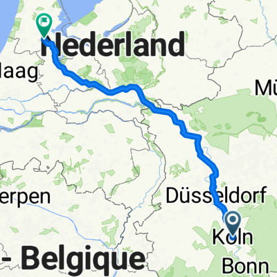
- 61.9 km
- Distance
- 87 m
- Ascent
- 97 m
- Descent
- ---
- Avg. speed
- ---
- Max. altitude

Route quality
Waytypes & surfaces along the route
Waytypes
Path
30.9 km
(50 %)
Track
10.9 km
(18 %)
Surfaces
Paved
48.2 km
(78 %)
Unpaved
6.9 km
(11 %)
Asphalt
38.3 km
(62 %)
Paving stones
6.8 km
(11 %)
Route highlights
Points of interest along the route

Point of interest after 28.1 km
Geologischer Park, Im Tannenbusch
Continue with Bikemap
Use, edit, or download this cycling route
You would like to ride Geopark Tannenbusch or customize it for your own trip? Here is what you can do with this Bikemap route:
Free features
- Save this route as favorite or in collections
- Copy & plan your own version of this route
- Sync your route with Garmin or Wahoo
Premium features
Free trial for 3 days, or one-time payment. More about Bikemap Premium.
- Navigate this route on iOS & Android
- Export a GPX / KML file of this route
- Create your custom printout (try it for free)
- Download this route for offline navigation
Discover more Premium features.
Get Bikemap PremiumFrom our community
Other popular routes starting in Neustadt/Nord
 Mediapark bis zum Kloster Knechtsteden
- Distance
- 40.9 km
- Ascent
- 77 m
- Descent
- 90 m
- Location
- Neustadt/Nord, North Rhine-Westphalia, Germany
 Route nach Arnhem
- Distance
- 173.9 km
- Ascent
- 278 m
- Descent
- 321 m
- Location
- Neustadt/Nord, North Rhine-Westphalia, Germany
 Kottenforst Ville-Seen Radweg
- Distance
- 60.3 km
- Ascent
- 177 m
- Descent
- 184 m
- Location
- Neustadt/Nord, North Rhine-Westphalia, Germany
 Geopark Tannenbusch
- Distance
- 61.9 km
- Ascent
- 87 m
- Descent
- 97 m
- Location
- Neustadt/Nord, North Rhine-Westphalia, Germany
 Schloßpark Dyck
- Distance
- 64.1 km
- Ascent
- 112 m
- Descent
- 115 m
- Location
- Neustadt/Nord, North Rhine-Westphalia, Germany
 Köln Promenade
- Distance
- 18.8 km
- Ascent
- 153 m
- Descent
- 173 m
- Location
- Neustadt/Nord, North Rhine-Westphalia, Germany
 Kuln Amsterdam
- Distance
- 292.4 km
- Ascent
- 97 m
- Descent
- 149 m
- Location
- Neustadt/Nord, North Rhine-Westphalia, Germany
 Schloss Paffendorf
- Distance
- 61.9 km
- Ascent
- 284 m
- Descent
- 286 m
- Location
- Neustadt/Nord, North Rhine-Westphalia, Germany
Open it in the app