Waldachtalrunde
A cycling route starting in Schopfloch, Baden-Württemberg, Germany.
Overview
About this route
Da es sich um eine Rundstrecke handelt, kann jeder Punkt der Strecke für den Einstieg genutzt werden. Ebenso kann die Strecke auch gegen den Uhrzeiger gefahren werden.
- -:--
- Duration
- 28.8 km
- Distance
- 537 m
- Ascent
- 478 m
- Descent
- ---
- Avg. speed
- 664 m
- Avg. speed
Route quality
Waytypes & surfaces along the route
Waytypes
Track
26.2 km
(91 %)
Quiet road
0.8 km
(3 %)
Surfaces
Paved
10.7 km
(37 %)
Unpaved
15.5 km
(54 %)
Gravel
11.6 km
(40 %)
Paved (undefined)
6 km
(21 %)
Continue with Bikemap
Use, edit, or download this cycling route
You would like to ride Waldachtalrunde or customize it for your own trip? Here is what you can do with this Bikemap route:
Free features
- Save this route as favorite or in collections
- Copy & plan your own version of this route
- Sync your route with Garmin or Wahoo
Premium features
Free trial for 3 days, or one-time payment. More about Bikemap Premium.
- Navigate this route on iOS & Android
- Export a GPX / KML file of this route
- Create your custom printout (try it for free)
- Download this route for offline navigation
Discover more Premium features.
Get Bikemap PremiumFrom our community
Other popular routes starting in Schopfloch
- Waldachtour Lützenhardt-Hallwangen-Schopfloch-Lützenhardt
- Distance
- 17.9 km
- Ascent
- 262 m
- Descent
- 267 m
- Location
- Schopfloch, Baden-Württemberg, Germany
- 30km Hausrunde mir Massholder Passhöhe
- Distance
- 28.6 km
- Ascent
- 480 m
- Descent
- 480 m
- Location
- Schopfloch, Baden-Württemberg, Germany
- Ins Tal der Waldach
- Distance
- 17.2 km
- Ascent
- 357 m
- Descent
- 357 m
- Location
- Schopfloch, Baden-Württemberg, Germany
- Highspeed im Wald
- Distance
- 26.4 km
- Ascent
- 355 m
- Descent
- 355 m
- Location
- Schopfloch, Baden-Württemberg, Germany
- Schönes Waldachtal 1.0
- Distance
- 14.4 km
- Ascent
- 296 m
- Descent
- 296 m
- Location
- Schopfloch, Baden-Württemberg, Germany
- Freudenstadt Memmingen Munich 300 km 1200 m
- Distance
- 278.2 km
- Ascent
- 794 m
- Descent
- 969 m
- Location
- Schopfloch, Baden-Württemberg, Germany
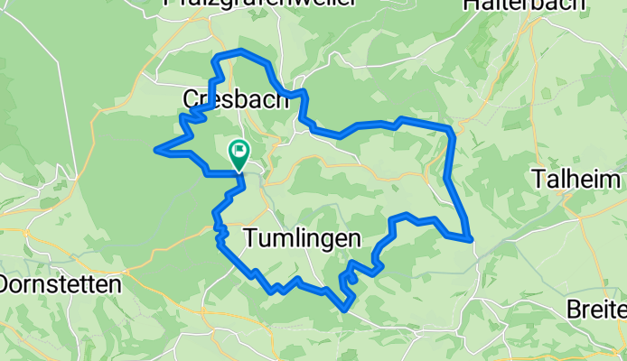
- Durchs Waldachtal und durchs Steinachtal
- Distance
- 37.6 km
- Ascent
- 302 m
- Descent
- 302 m
- Location
- Schopfloch, Baden-Württemberg, Germany
- Waldachtalrunde
- Distance
- 28.8 km
- Ascent
- 537 m
- Descent
- 478 m
- Location
- Schopfloch, Baden-Württemberg, Germany
Open it in the app