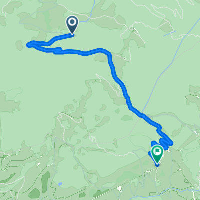
vandans-heinrich hütter
A cycling route starting in Vandans, Vorarlberg, Austria.
Overview
About this route
Access to the Heinrich Hütter hut from Vandans
- -:--
- Duration
- 10.4 km
- Distance
- 1,156 m
- Ascent
- 26 m
- Descent
- ---
- Avg. speed
- ---
- Max. altitude
Continue with Bikemap
Use, edit, or download this cycling route
You would like to ride vandans-heinrich hütter or customize it for your own trip? Here is what you can do with this Bikemap route:
Free features
- Save this route as favorite or in collections
- Copy & plan your own version of this route
- Sync your route with Garmin or Wahoo
Premium features
Free trial for 3 days, or one-time payment. More about Bikemap Premium.
- Navigate this route on iOS & Android
- Export a GPX / KML file of this route
- Create your custom printout (try it for free)
- Download this route for offline navigation
Discover more Premium features.
Get Bikemap PremiumFrom our community
Other popular routes starting in Vandans
- Die Golm rauf und runter
- Distance
- 24 km
- Ascent
- 1,262 m
- Descent
- 1,265 m
- Location
- Vandans, Vorarlberg, Austria
- MTB Hillclimb Vandans-Matschwitz
- Distance
- 10.6 km
- Ascent
- 1,023 m
- Descent
- 128 m
- Location
- Vandans, Vorarlberg, Austria
- vandans-heinrich hütter
- Distance
- 10.4 km
- Ascent
- 1,156 m
- Descent
- 26 m
- Location
- Vandans, Vorarlberg, Austria
- Ins Brandnertal CLONED FROM ROUTE 1733641
- Distance
- 54.7 km
- Ascent
- 1,080 m
- Descent
- 1,080 m
- Location
- Vandans, Vorarlberg, Austria
- MTB Hillclimb Ganeu-Matschwitz
- Distance
- 3.1 km
- Ascent
- 329 m
- Descent
- 36 m
- Location
- Vandans, Vorarlberg, Austria
- 20160304_091029.gpx
- Distance
- 16.5 km
- Ascent
- 1,658 m
- Descent
- 2,072 m
- Location
- Vandans, Vorarlberg, Austria
- Lindauer Hütte
- Distance
- 12 km
- Ascent
- 1,111 m
- Descent
- 5 m
- Location
- Vandans, Vorarlberg, Austria
- Montafon Fun neu
- Distance
- 84.3 km
- Ascent
- 3,375 m
- Descent
- 3,371 m
- Location
- Vandans, Vorarlberg, Austria
Open it in the app