Szkolna do Książenicka 54A
- 276.9 km
- 1,742 m
- 2,142 m
- Krynica-Zdrój, Lesser Poland Voivodeship, Poland
A cycling route starting in Krynica-Zdrój, Lesser Poland Voivodeship, Poland.
Overview
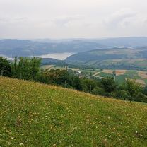
Super route with strong climbs, strong and fast descents, leading from about 650 m above sea level to about 1100 m above sea level (Jaworzyna Krynicka). GPS calculated 63.5 km, travel time 6:30 plus a break. A demanding route. The climb to Jaworzyna is about 6 km long and takes about 45-60 minutes of effort. Please read the information on the POI map. It is worth stopping at the shelter on the Łaboskiej plateau for lunch and to replenish supplies. The further route follows a blue trail; unfortunately, at one point, it is necessary to carry the bike. However, I do not recommend this part because you have to descend a wall that has an inclination of up to 36 degrees. Unfortunately, there is about 200 m to descend counted in the vertical, descent time is about 25-30 minutes without proper off-road shoes, you shouldn't even think about it. Lots of large loose stones and protruding tree roots which, if it's wet, turn into a slippery surface.
A long stretch of the route runs on asphalt for about 40 km and has beautiful views of the Poprad.
created this 12 years ago
Route highlights
Początek dość ciężkiego podjazdu
dystans ok 6km pod góre czas ok 0:45-1:00 na rowerze
Schronisko na Hali Łabowskiej
Niebieski szlak pieszy Uwaga trasa wiedzie z pięknymi widokami, ale jest bardzo ostre ZEJŚCIE nie nadające się na rower. Proszę przeczytać kolejny POI
UWAGA Bardzo ostre zejście - bRAK możliwości jazdy na rowerze Nachylenie sięgające do 36%!!!! Rower trzeba częśto znosić Absolutnie nie jechać tą trasę po deszczach - bardzo śliskie zbocze z dużymi luznymi kamieniami, wystające korzenie. Nasze zejście trwało ok 25-30min, w pionie ok 200m
Continue with Bikemap
You would like to ride Czarny Potok_Jaworzyna Krynicka_Runek_Hala Łabowska_Łomnica Zdrój_Wierchomla WIelka_Muszyna_Krynica_Czarny Potok or customize it for your own trip? Here is what you can do with this Bikemap route:
Free trial for 3 days, or one-time payment. More about Bikemap Premium.
Discover more Premium features.
Get Bikemap PremiumFrom our community
Open it in the app