

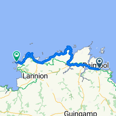
Paimpol - Ile Grande 11.06.2013 / 4th Stage
A cycling route starting in Paimpol, Brittany Region, France.
Overview
About this route
<div style="margin: 0px; padding: 0px; border: 0px; outline: 0px; color: rgb(102, 102, 102); font-family: Helvetica, 'Helvetica Neue', Arial, sans-serif; line-height: 20px;"> Cesta zpevněná po silnici, občas polní a tomu podobné cesty.</div> <div style="margin: 0px; padding: 0px; border: 0px; outline: 0px; color: rgb(102, 102, 102); font-family: Helvetica, 'Helvetica Neue', Arial, sans-serif; line-height: 20px;"> </div> <div style="margin: 0px; padding: 0px; border: 0px; outline: 0px; color: rgb(102, 102, 102); font-family: Helvetica, 'Helvetica Neue', Arial, sans-serif; line-height: 20px;"> Zajímavosti na trase :</div> <div style="margin: 0px; padding: 0px; border: 0px; outline: 0px; color: rgb(102, 102, 102); font-family: Helvetica, 'Helvetica Neue', Arial, sans-serif; line-height: 20px;"> - 18.km : zbytek starého mostu - město Tréguier</div> <div style="margin: 0px; padding: 0px; border: 0px; outline: 0px; color: rgb(102, 102, 102); font-family: Helvetica, 'Helvetica Neue', Arial, sans-serif; line-height: 20px;"> - 20.km : cathedrale Saint-Tugdual - město Tréguier</div> <div style="margin: 0px; padding: 0px; border: 0px; outline: 0px; color: rgb(102, 102, 102); font-family: Helvetica, 'Helvetica Neue', Arial, sans-serif; line-height: 20px;"> - 34.km : výběžek Le Gouffre (severně od Plougrescant)</div> <div style="margin: 0px; padding: 0px; border: 0px; outline: 0px; color: rgb(102, 102, 102); font-family: Helvetica, 'Helvetica Neue', Arial, sans-serif; line-height: 20px;"> - 44.km : přejezd přes moře není po mostu ale po pláži během odlivu (možno do cca 19-ti hodin)</div> <div style="margin: 0px; padding: 0px; border: 0px; outline: 0px; color: rgb(102, 102, 102); font-family: Helvetica, 'Helvetica Neue', Arial, sans-serif; line-height: 20px;"> - 65.km : vyhlídka + maják De Men Ruz</div> <div style="margin: 0px; padding: 0px; border: 0px; outline: 0px; color: rgb(102, 102, 102); font-family: Helvetica, 'Helvetica Neue', Arial, sans-serif; line-height: 20px;"> - 71.km : ostrov Ile Renote (příjemný výlet po mini ostrůvku, svlažení nohou nebo i celého těla, nějaký ten Dolmen)</div> <div style="margin: 0px; padding: 0px; border: 0px; outline: 0px; color: rgb(102, 102, 102); font-family: Helvetica, 'Helvetica Neue', Arial, sans-serif; line-height: 20px;"> </div> <div style="margin: 0px; padding: 0px; border: 0px; outline: 0px; color: rgb(102, 102, 102); font-family: Helvetica, 'Helvetica Neue', Arial, sans-serif; line-height: 20px;"> Údaje z cyklocomputeru:</div> <div style="margin: 0px; padding: 0px; border: 0px; outline: 0px; color: rgb(102, 102, 102); font-family: Helvetica, 'Helvetica Neue', Arial, sans-serif; line-height: 20px;"> délka 84,08 km / nastoupáno 1161 m / čas 4:51:23 hod</div> <div style="margin: 0px; padding: 0px; border: 0px; outline: 0px; color: rgb(102, 102, 102); font-family: Helvetica, 'Helvetica Neue', Arial, sans-serif; line-height: 20px;"> </div> <div style="margin: 0px; padding: 0px; border: 0px; outline: 0px; color: rgb(102, 102, 102); font-family: Helvetica, 'Helvetica Neue', Arial, sans-serif; line-height: 20px;"> CampingMunicipal du Dourlin (Ile Grande) :</div> <div style="margin: 0px; padding: 0px; border: 0px; outline: 0px; color: rgb(102, 102, 102); font-family: Helvetica, 'Helvetica Neue', Arial, sans-serif; line-height: 20px;"> <span style="margin: 0px; padding: 0px; border: 0px; outline: 0px; font-size: 11pt; line-height: 17px; font-family: Calibri, sans-serif;">čistý kemp; teplá voda; stojan s elektrikou za poplatek; sprchy O.K.</span></div> <div style="margin: 0px; padding: 0px; border: 0px; outline: 0px; color: rgb(102, 102, 102); font-family: Helvetica, 'Helvetica Neue', Arial, sans-serif; line-height: 20px;"> </div> <div style="margin: 0px; padding: 0px; border: 0px; outline: 0px; color: rgb(102, 102, 102); font-family: Helvetica, 'Helvetica Neue', Arial, sans-serif; line-height: 20px;"> <span style="font-family: Calibri, sans-serif; font-size: 15px; line-height: 17px;">V těsné blízkosti kempu byla rozjetá stavba a dle správce by nás měly v 7 hod ráno budit stroje - francouzi asi zaspali a tak bylo ráno ticho. Kemp se nachází hned na pobřeží a tak jihozápadní vítr jsme měli hned z první ruky. Pokud by tento kemp nevyhovoval, byl ještě jeden otvřený u odbočky na Ile Grande v městečku Penvern a na jeden byl ukazatel přímo na ostrově Ile Grande na jeho západní části.</span></div>
- -:--
- Duration
- 82.9 km
- Distance
- 469 m
- Ascent
- 478 m
- Descent
- ---
- Avg. speed
- ---
- Max. altitude

Route quality
Waytypes & surfaces along the route
Waytypes
Quiet road
38.2 km
(46 %)
Road
17 km
(21 %)
Surfaces
Paved
49.5 km
(60 %)
Unpaved
5.8 km
(7 %)
Asphalt
48.5 km
(58 %)
Gravel
4.4 km
(5 %)
Continue with Bikemap
Use, edit, or download this cycling route
You would like to ride Paimpol - Ile Grande 11.06.2013 / 4th Stage or customize it for your own trip? Here is what you can do with this Bikemap route:
Free features
- Save this route as favorite or in collections
- Copy & plan your own version of this route
- Split it into stages to create a multi-day tour
- Sync your route with Garmin or Wahoo
Premium features
Free trial for 3 days, or one-time payment. More about Bikemap Premium.
- Navigate this route on iOS & Android
- Export a GPX / KML file of this route
- Create your custom printout (try it for free)
- Download this route for offline navigation
Discover more Premium features.
Get Bikemap PremiumFrom our community
Other popular routes starting in Paimpol
 Cotes d'Armor_PAIMPOL-CRECH GOULARD-intérieur
- Distance
- 33.4 km
- Ascent
- 234 m
- Descent
- 205 m
- Location
- Paimpol, Brittany Region, France
 10. Paimpol - St. Brieuc
- Distance
- 56.8 km
- Ascent
- 511 m
- Descent
- 450 m
- Location
- Paimpol, Brittany Region, France
 Paimpol - Trèguier
- Distance
- 18.1 km
- Ascent
- 151 m
- Descent
- 132 m
- Location
- Paimpol, Brittany Region, France
 PAIMPOL-CRECH GOULARD—petites routes cotieres
- Distance
- 64.7 km
- Ascent
- 501 m
- Descent
- 477 m
- Location
- Paimpol, Brittany Region, France
 Ride des Mousettes - Day 3
- Distance
- 149.8 km
- Ascent
- 597 m
- Descent
- 574 m
- Location
- Paimpol, Brittany Region, France
 R2: Paimpol-Le Mûr de Bretagne
- Distance
- 178.4 km
- Ascent
- 912 m
- Descent
- 797 m
- Location
- Paimpol, Brittany Region, France
 Paimpol - Ile Grande 11.06.2013 / 4th Stage
- Distance
- 82.9 km
- Ascent
- 469 m
- Descent
- 478 m
- Location
- Paimpol, Brittany Region, France
- Paimpol - Lanvollon - Paimpol
- Distance
- 79.4 km
- Ascent
- ---
- Descent
- ---
- Location
- Paimpol, Brittany Region, France
Open it in the app