
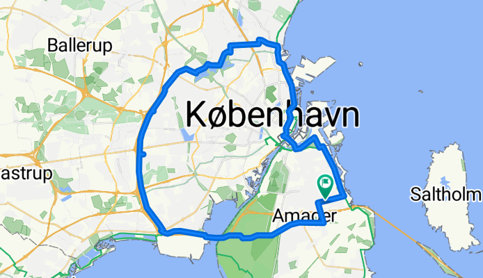
Vestvolden rundt
A cycling route starting in Tårnby, Capital Region, Denmark.
Overview
About this route
Start and finish are at the Airport Dan Hotel
Mostly paved, but not 100%. Includes much of the very pleasant trail along the old westerly fortifications. Bike path deviates R from Vejlands Alee @ Center Blvd; not well marked --- you DON'T have to use the bus lane; actual bike path is just north; separated by trees; quite nice East to miss: Vestvolden route has the rider crossing Gammel Koge Landevej, turning right, then turning left after crossing the moat. A seeming dead end into a RR track may be encountered if GPS set too far 'out' -- crossing is an underpass a couple humdred meters to the East 156 Roskildervej is crossed on a bike/ped bridge; trail cutoff is easy to miss E47 Jyllingevej crossing is via a bike bridge with steps and a single wheel trough; too steep for some cargo bikes (eg Winther Kangaroo) to get through; bad for many trikes and velomobiles; unobstructed (but unprotected, uncontrolled and probably illegal) grade crosssing can be made less than 100m East Trail dead-ends at rail line shortly before 211; back-track is short if you miss the turn-off to the bike overpass (gg) Label is "> Utterslev Mose" Total was a bit over 36 miles when we did it (some detours) (cloned from route 338766)- -:--
- Duration
- 51.3 km
- Distance
- 50 m
- Ascent
- 50 m
- Descent
- ---
- Avg. speed
- ---
- Max. altitude

Route quality
Waytypes & surfaces along the route
Waytypes
Cycleway
20.5 km
(40 %)
Road
16.9 km
(33 %)
Surfaces
Paved
49.7 km
(97 %)
Unpaved
1 km
(2 %)
Asphalt
49.7 km
(97 %)
Gravel
1 km
(2 %)
Undefined
0.5 km
(1 %)
Continue with Bikemap
Use, edit, or download this cycling route
You would like to ride Vestvolden rundt or customize it for your own trip? Here is what you can do with this Bikemap route:
Free features
- Save this route as favorite or in collections
- Copy & plan your own version of this route
- Sync your route with Garmin or Wahoo
Premium features
Free trial for 3 days, or one-time payment. More about Bikemap Premium.
- Navigate this route on iOS & Android
- Export a GPX / KML file of this route
- Create your custom printout (try it for free)
- Download this route for offline navigation
Discover more Premium features.
Get Bikemap PremiumFrom our community
Other popular routes starting in Tårnby
 Vestvolden rundt langt
- Distance
- 85.9 km
- Ascent
- 177 m
- Descent
- 178 m
- Location
- Tårnby, Capital Region, Denmark
 Hvidovre turen
- Distance
- 22.9 km
- Ascent
- 13 m
- Descent
- 14 m
- Location
- Tårnby, Capital Region, Denmark
 Richard Mortensens Vej 73, København S to Richard Mortensens Vej 80, København S
- Distance
- 29.4 km
- Ascent
- 73 m
- Descent
- 71 m
- Location
- Tårnby, Capital Region, Denmark
 Da Dæmningsvej, Copenaghen a Strandstien, Dragør
- Distance
- 19.3 km
- Ascent
- 0 m
- Descent
- 3 m
- Location
- Tårnby, Capital Region, Denmark
 AC Hotel to Helsingør
- Distance
- 50.7 km
- Ascent
- 96 m
- Descent
- 95 m
- Location
- Tårnby, Capital Region, Denmark
 Amager rundt
- Distance
- 50 km
- Ascent
- 22 m
- Descent
- 19 m
- Location
- Tårnby, Capital Region, Denmark
 Rundt om havnen
- Distance
- 23.5 km
- Ascent
- 13 m
- Descent
- 13 m
- Location
- Tårnby, Capital Region, Denmark
 40 km rundt i StorKBH
- Distance
- 39.7 km
- Ascent
- 59 m
- Descent
- 60 m
- Location
- Tårnby, Capital Region, Denmark
Open it in the app