

Šumava
A cycling route starting in Kájov, Jihočeský kraj, Czechia.
Overview
About this route
<p>
<span class='st'><em>Šumava</em> </span></p>
Translated, show original (Polish)- -:--
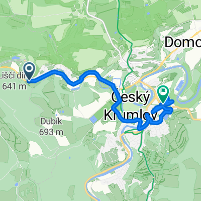
- Duration
- 41.3 km
- Distance
- 666 m
- Ascent
- 666 m
- Descent
- ---
- Avg. speed
- ---
- Max. altitude

Continue with Bikemap
Use, edit, or download this cycling route
You would like to ride Šumava or customize it for your own trip? Here is what you can do with this Bikemap route:
Free features
- Save this route as favorite or in collections
- Copy & plan your own version of this route
- Sync your route with Garmin or Wahoo
Premium features
Free trial for 3 days, or one-time payment. More about Bikemap Premium.
- Navigate this route on iOS & Android
- Export a GPX / KML file of this route
- Create your custom printout (try it for free)
- Download this route for offline navigation
Discover more Premium features.
Get Bikemap PremiumFrom our community
Other popular routes starting in Kájov
 cesky dél
- Distance
- 93.4 km
- Ascent
- 1,049 m
- Descent
- 1,041 m
- Location
- Kájov, Jihočeský kraj, Czechia
 Závod Kájov-Prachatice-Kleť
- Distance
- 78.3 km
- Ascent
- 1,296 m
- Descent
- 751 m
- Location
- Kájov, Jihočeský kraj, Czechia
 Kájov to Nemocniční
- Distance
- 9.9 km
- Ascent
- 405 m
- Descent
- 448 m
- Location
- Kájov, Jihočeský kraj, Czechia
 Šumava
- Distance
- 41.3 km
- Ascent
- 666 m
- Descent
- 666 m
- Location
- Kájov, Jihočeský kraj, Czechia
 Klet ring
- Distance
- 45.1 km
- Ascent
- 546 m
- Descent
- 444 m
- Location
- Kájov, Jihočeský kraj, Czechia
 NEDELE VVP
- Distance
- 40 km
- Ascent
- 642 m
- Descent
- 637 m
- Location
- Kájov, Jihočeský kraj, Czechia
 Snail-like route in Krumlov
- Distance
- 54.9 km
- Ascent
- 675 m
- Descent
- 724 m
- Location
- Kájov, Jihočeský kraj, Czechia
 2010_01 Kájov_Český Krumlov pěšky
- Distance
- 11.3 km
- Ascent
- 298 m
- Descent
- 288 m
- Location
- Kájov, Jihočeský kraj, Czechia
Open it in the app