

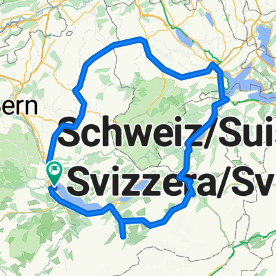
Gurnigel
A cycling route starting in Thun, Canton of Bern, Switzerland.
Overview
About this route
Passfahrtfahrt im Gurnigel Gantrischgebiet
- -:--
- Duration
- 100.8 km
- Distance
- 1,600 m
- Ascent
- 1,600 m
- Descent
- ---
- Avg. speed
- ---
- Max. altitude

Route quality
Waytypes & surfaces along the route
Waytypes
Road
38.3 km
(38 %)
Quiet road
12.1 km
(12 %)
Surfaces
Paved
49.4 km
(49 %)
Unpaved
1 km
(1 %)
Asphalt
49.4 km
(49 %)
Gravel
1 km
(1 %)
Undefined
50.4 km
(50 %)
Continue with Bikemap
Use, edit, or download this cycling route
You would like to ride Gurnigel or customize it for your own trip? Here is what you can do with this Bikemap route:
Free features
- Save this route as favorite or in collections
- Copy & plan your own version of this route
- Split it into stages to create a multi-day tour
- Sync your route with Garmin or Wahoo
Premium features
Free trial for 3 days, or one-time payment. More about Bikemap Premium.
- Navigate this route on iOS & Android
- Export a GPX / KML file of this route
- Create your custom printout (try it for free)
- Download this route for offline navigation
Discover more Premium features.
Get Bikemap PremiumFrom our community
Other popular routes starting in Thun
 Alpine Tour: Thun - Fluhli
- Distance
- 47.7 km
- Ascent
- 1,186 m
- Descent
- 640 m
- Location
- Thun, Canton of Bern, Switzerland
 Martinstrasse, Thun nach Rubigen
- Distance
- 28.3 km
- Ascent
- 122 m
- Descent
- 173 m
- Location
- Thun, Canton of Bern, Switzerland
 Aaretal Tour bis Rubigen, retour über Kiesen - Jaberg - Kirchdorf
- Distance
- 42.4 km
- Ascent
- 408 m
- Descent
- 410 m
- Location
- Thun, Canton of Bern, Switzerland
 Thun - Willisau
- Distance
- 249 km
- Ascent
- 8,115 m
- Descent
- 8,117 m
- Location
- Thun, Canton of Bern, Switzerland
 Haltenegg
- Distance
- 20.6 km
- Ascent
- 656 m
- Descent
- 658 m
- Location
- Thun, Canton of Bern, Switzerland
 RR 2016_2. Tag_24.02.2016
- Distance
- 39.1 km
- Ascent
- 405 m
- Descent
- 400 m
- Location
- Thun, Canton of Bern, Switzerland
 Blueme I
- Distance
- 26.2 km
- Ascent
- 858 m
- Descent
- 823 m
- Location
- Thun, Canton of Bern, Switzerland
 Auf und Ab im Raum Thun
- Distance
- 37.2 km
- Ascent
- 378 m
- Descent
- 377 m
- Location
- Thun, Canton of Bern, Switzerland
Open it in the app