
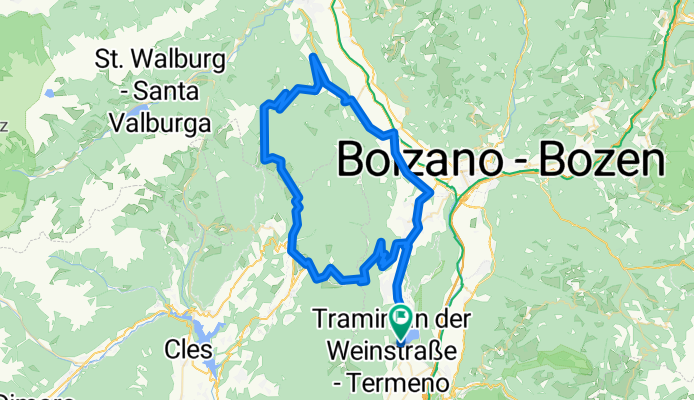
Lago Caldaro - Mendel - Gampen - Meran - Kaltern
A cycling route starting in Termeno, Trentino-Alto Adige, Italy.
Overview
About this route
Schöne Runde mit abschließender Fahrt durch die Apfel-Felder.
Landschaftlich nicht auf dem Niveau einer Sella-Runde, aber immernoch super.
(Regenerationsrunde für Hartgesottene)
- -:--
- Duration
- 86.8 km
- Distance
- 2,638 m
- Ascent
- 2,495 m
- Descent
- ---
- Avg. speed
- 1,536 m
- Max. altitude

Route quality
Waytypes & surfaces along the route
Waytypes
Busy road
74.6 km
(86 %)
Quiet road
3.6 km
(4 %)
Surfaces
Paved
77.3 km
(89 %)
Unpaved
0.4 km
(<1 %)
Asphalt
77.3 km
(89 %)
Unpaved (undefined)
0.4 km
(<1 %)
Undefined
9.1 km
(10 %)
Continue with Bikemap
Use, edit, or download this cycling route
You would like to ride Lago Caldaro - Mendel - Gampen - Meran - Kaltern or customize it for your own trip? Here is what you can do with this Bikemap route:
Free features
- Save this route as favorite or in collections
- Copy & plan your own version of this route
- Split it into stages to create a multi-day tour
- Sync your route with Garmin or Wahoo
Premium features
Free trial for 3 days, or one-time payment. More about Bikemap Premium.
- Navigate this route on iOS & Android
- Export a GPX / KML file of this route
- Create your custom printout (try it for free)
- Download this route for offline navigation
Discover more Premium features.
Get Bikemap PremiumFrom our community
Other popular routes starting in Termeno
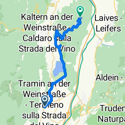 Tramin-Montiggler Seen
- Distance
- 16.9 km
- Ascent
- 354 m
- Descent
- 81 m
- Location
- Termeno, Trentino-Alto Adige, Italy
 RSCN - Tramin - Cles
- Distance
- 97.2 km
- Ascent
- 1,496 m
- Descent
- 1,496 m
- Location
- Termeno, Trentino-Alto Adige, Italy
 Tramin-Gampenpass-Mendelpass
- Distance
- 107.7 km
- Ascent
- 1,861 m
- Descent
- 1,861 m
- Location
- Termeno, Trentino-Alto Adige, Italy
 Lago Caldaro - Mendel - Gampen - Meran - Kaltern
- Distance
- 86.8 km
- Ascent
- 2,638 m
- Descent
- 2,495 m
- Location
- Termeno, Trentino-Alto Adige, Italy
 Grauner Joch Südtirol
- Distance
- 33.7 km
- Ascent
- 1,898 m
- Descent
- 1,898 m
- Location
- Termeno, Trentino-Alto Adige, Italy
 RSCN - Tramin - Lavis - Altrei - Auer
- Distance
- 96.3 km
- Ascent
- 1,221 m
- Descent
- 1,221 m
- Location
- Termeno, Trentino-Alto Adige, Italy
 Traminer Hof - Zur Brücke
- Distance
- 14 km
- Ascent
- 19 m
- Descent
- 56 m
- Location
- Termeno, Trentino-Alto Adige, Italy
 Mendelrunde
- Distance
- 107.6 km
- Ascent
- 2,250 m
- Descent
- 2,279 m
- Location
- Termeno, Trentino-Alto Adige, Italy
Open it in the app