

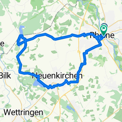
2013 - Ems - 2. Tag - Rheine - Vadrup
A cycling route starting in Rheine, North Rhine-Westphalia, Germany.
Overview
About this route
Im Wesentlichen auf dem Ems-Radweg
- -:--
- Duration
- 59.5 km
- Distance
- 87 m
- Ascent
- 73 m
- Descent
- ---
- Avg. speed
- ---
- Max. altitude

Route quality
Waytypes & surfaces along the route
Waytypes
Quiet road
33.8 km
(57 %)
Access road
8.1 km
(14 %)
Surfaces
Paved
47 km
(79 %)
Unpaved
2 km
(3 %)
Asphalt
41.5 km
(70 %)
Paving stones
3.3 km
(5 %)
Continue with Bikemap
Use, edit, or download this cycling route
You would like to ride 2013 - Ems - 2. Tag - Rheine - Vadrup or customize it for your own trip? Here is what you can do with this Bikemap route:
Free features
- Save this route as favorite or in collections
- Copy & plan your own version of this route
- Sync your route with Garmin or Wahoo
Premium features
Free trial for 3 days, or one-time payment. More about Bikemap Premium.
- Navigate this route on iOS & Android
- Export a GPX / KML file of this route
- Create your custom printout (try it for free)
- Download this route for offline navigation
Discover more Premium features.
Get Bikemap PremiumFrom our community
Other popular routes starting in Rheine
 Rheine-Ewige Liebe
- Distance
- 29.9 km
- Ascent
- 72 m
- Descent
- 69 m
- Location
- Rheine, North Rhine-Westphalia, Germany
 Hase-Ems-Weg - 1 Tag
- Distance
- 41.7 km
- Ascent
- 63 m
- Descent
- 75 m
- Location
- Rheine, North Rhine-Westphalia, Germany
 Nasses Eck - Elte
- Distance
- 30 km
- Ascent
- 58 m
- Descent
- 56 m
- Location
- Rheine, North Rhine-Westphalia, Germany
 Elte-Emsdetten-Neuenkirchen-Tour
- Distance
- 44.7 km
- Ascent
- 84 m
- Descent
- 83 m
- Location
- Rheine, North Rhine-Westphalia, Germany
 Rheine-Hörstel-Nasses Dreieck CLONED FROM ROUTE 71643
- Distance
- 32.4 km
- Ascent
- 61 m
- Descent
- 65 m
- Location
- Rheine, North Rhine-Westphalia, Germany
 Hermannsweg I
- Distance
- 46.5 km
- Ascent
- 172 m
- Descent
- 171 m
- Location
- Rheine, North Rhine-Westphalia, Germany
 Rheine Spelle Moorcafe
- Distance
- 40.3 km
- Ascent
- 65 m
- Descent
- 65 m
- Location
- Rheine, North Rhine-Westphalia, Germany
 Rundstrecke Rheine Mesum Elte
- Distance
- 32.5 km
- Ascent
- 81 m
- Descent
- 81 m
- Location
- Rheine, North Rhine-Westphalia, Germany
Open it in the app