

Etape 8 par le Mont Ventoux
A cycling route starting in Maubec, Provence-Alpes-Côte d'Azur Region, France.
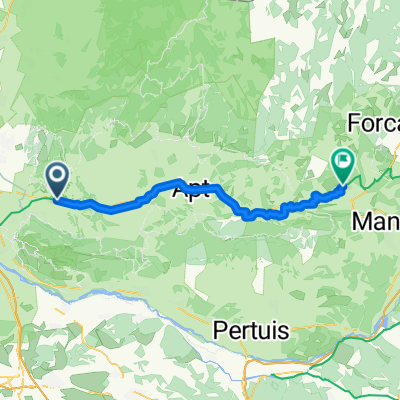
Overview
About this route
The day of glory has arrived
- -:--
- Duration
- 114 km
- Distance
- 2,108 m
- Ascent
- 1,842 m
- Descent
- ---
- Avg. speed
- ---
- Max. altitude
Route quality
Waytypes & surfaces along the route
Waytypes
Road
18.2 km
(16 %)
Quiet road
8 km
(7 %)
Surfaces
Paved
98 km
(86 %)
Asphalt
98 km
(86 %)
Undefined
16 km
(14 %)
Continue with Bikemap
Use, edit, or download this cycling route
You would like to ride Etape 8 par le Mont Ventoux or customize it for your own trip? Here is what you can do with this Bikemap route:
Free features
- Save this route as favorite or in collections
- Copy & plan your own version of this route
- Split it into stages to create a multi-day tour
- Sync your route with Garmin or Wahoo
Premium features
Free trial for 3 days, or one-time payment. More about Bikemap Premium.
- Navigate this route on iOS & Android
- Export a GPX / KML file of this route
- Create your custom printout (try it for free)
- Download this route for offline navigation
Discover more Premium features.
Get Bikemap PremiumFrom our community
Other popular routes starting in Maubec
 MAUBEC TOUR DE 2
- Distance
- 22.4 km
- Ascent
- 132 m
- Descent
- 127 m
- Location
- Maubec, Provence-Alpes-Côte d'Azur Region, France
 Provance
- Distance
- 49.7 km
- Ascent
- 610 m
- Descent
- 603 m
- Location
- Maubec, Provence-Alpes-Côte d'Azur Region, France
 Indochinois
- Distance
- 65 km
- Ascent
- 839 m
- Descent
- 837 m
- Location
- Maubec, Provence-Alpes-Côte d'Azur Region, France
 Gordes-Murs-St Saturin-Apt
- Distance
- 75.7 km
- Ascent
- 927 m
- Descent
- 927 m
- Location
- Maubec, Provence-Alpes-Côte d'Azur Region, France
 24-15 Coustellet - Reillanne
- Distance
- 56.7 km
- Ascent
- 724 m
- Descent
- 401 m
- Location
- Maubec, Provence-Alpes-Côte d'Azur Region, France
 Etape 8 par le Mont Ventoux
- Distance
- 114 km
- Ascent
- 2,108 m
- Descent
- 1,842 m
- Location
- Maubec, Provence-Alpes-Côte d'Azur Region, France
 Avignon bis Radroute
- Distance
- 26.9 km
- Ascent
- 12 m
- Descent
- 89 m
- Location
- Maubec, Provence-Alpes-Côte d'Azur Region, France
 Maubec - Ralhana
- Distance
- 53.3 km
- Ascent
- 786 m
- Descent
- 333 m
- Location
- Maubec, Provence-Alpes-Côte d'Azur Region, France
Open it in the app