

2013_06 Provence
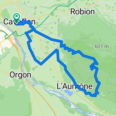
Cavaillon_Robion
A cycling route starting in Cavaillon, Provence-Alpes-Côte d'Azur Region, France.
Overview
About this route
<span class="info date">21. června 2013. </span>S Věrou. Přes Malý Luberon.
- -:--
- Duration
- 73.8 km
- Distance
- 891 m
- Ascent
- 873 m
- Descent
- ---
- Avg. speed
- ---
- Max. altitude

Part of
2013_06 Provence
8 stages
Route quality
Waytypes & surfaces along the route
Waytypes
Quiet road
26.6 km
(36 %)
Road
25.8 km
(35 %)
Surfaces
Paved
45 km
(61 %)
Unpaved
1.5 km
(2 %)
Asphalt
44.3 km
(60 %)
Concrete
0.7 km
(1 %)
Continue with Bikemap
Use, edit, or download this cycling route
You would like to ride Cavaillon_Robion or customize it for your own trip? Here is what you can do with this Bikemap route:
Free features
- Save this route as favorite or in collections
- Copy & plan your own version of this route
- Sync your route with Garmin or Wahoo
Premium features
Free trial for 3 days, or one-time payment. More about Bikemap Premium.
- Navigate this route on iOS & Android
- Export a GPX / KML file of this route
- Create your custom printout (try it for free)
- Download this route for offline navigation
Discover more Premium features.
Get Bikemap PremiumFrom our community
Other popular routes starting in Cavaillon
 cavaillon
- Distance
- 192.7 km
- Ascent
- 1,301 m
- Descent
- 1,301 m
- Location
- Cavaillon, Provence-Alpes-Côte d'Azur Region, France
 extra laatste dag
- Distance
- 40.9 km
- Ascent
- 100 m
- Descent
- 97 m
- Location
- Cavaillon, Provence-Alpes-Côte d'Azur Region, France
 cavaillon-beaumont de pertuis
- Distance
- 107.7 km
- Ascent
- 828 m
- Descent
- 535 m
- Location
- Cavaillon, Provence-Alpes-Côte d'Azur Region, France
 Cavaillon - Bonnieux
- Distance
- 61 km
- Ascent
- 542 m
- Descent
- 248 m
- Location
- Cavaillon, Provence-Alpes-Côte d'Azur Region, France
 Cavaillon nach Campingpaltz Saint Gilles
- Distance
- 67.2 km
- Ascent
- 59 m
- Descent
- 124 m
- Location
- Cavaillon, Provence-Alpes-Côte d'Azur Region, France
 Cavaillon-Cucuron_Etappe-1 by mnh
- Distance
- 48 km
- Ascent
- 644 m
- Descent
- 368 m
- Location
- Cavaillon, Provence-Alpes-Côte d'Azur Region, France
 Parcours n°1 - Cavaillon
- Distance
- 33.3 km
- Ascent
- 504 m
- Descent
- 507 m
- Location
- Cavaillon, Provence-Alpes-Côte d'Azur Region, France
 Orange_3d: Luberon-Tour ab Cavaillon
- Distance
- 75.8 km
- Ascent
- 444 m
- Descent
- 444 m
- Location
- Cavaillon, Provence-Alpes-Côte d'Azur Region, France
Open it in the app