

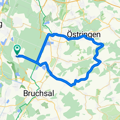
Forst/Eppingen/Ochsenburg/Forst
A cycling route starting in Hambrücken, Baden-Wurttemberg, Germany.
Overview
About this route
- -:--
- Duration
- 118.1 km
- Distance
- 902 m
- Ascent
- 874 m
- Descent
- ---
- Avg. speed
- 334 m
- Max. altitude
Route quality
Waytypes & surfaces along the route
Waytypes
Busy road
57.3 km
(48 %)
Road
30.1 km
(25 %)
Surfaces
Paved
110.7 km
(94 %)
Unpaved
1.3 km
(1 %)
Asphalt
108.2 km
(92 %)
Paving stones
1.7 km
(1 %)
Route highlights
Points of interest along the route
Point of interest after 4.8 km
Continue with Bikemap
Use, edit, or download this cycling route
You would like to ride Forst/Eppingen/Ochsenburg/Forst or customize it for your own trip? Here is what you can do with this Bikemap route:
Free features
- Save this route as favorite or in collections
- Copy & plan your own version of this route
- Split it into stages to create a multi-day tour
- Sync your route with Garmin or Wahoo
Premium features
Free trial for 3 days, or one-time payment. More about Bikemap Premium.
- Navigate this route on iOS & Android
- Export a GPX / KML file of this route
- Create your custom printout (try it for free)
- Download this route for offline navigation
Discover more Premium features.
Get Bikemap PremiumFrom our community
Other popular routes starting in Hambrücken
 L560, Waghäusel nach Landgraf-Georg-Straße 105, Darmstadt
- Distance
- 90 km
- Ascent
- 251 m
- Descent
- 208 m
- Location
- Hambrücken, Baden-Wurttemberg, Germany
 L556, Waghäusel nach Kreuzstraße 56, Waghäusel
- Distance
- 4.5 km
- Ascent
- 41 m
- Descent
- 68 m
- Location
- Hambrücken, Baden-Wurttemberg, Germany
 Forst/Eppingen/Ochsenburg/Forst
- Distance
- 118.1 km
- Ascent
- 902 m
- Descent
- 874 m
- Location
- Hambrücken, Baden-Wurttemberg, Germany
 Pastviny -
- Distance
- 58 km
- Ascent
- 309 m
- Descent
- 312 m
- Location
- Hambrücken, Baden-Wurttemberg, Germany
 Speyer-Hambrücken
- Distance
- 23.9 km
- Ascent
- 79 m
- Descent
- 81 m
- Location
- Hambrücken, Baden-Wurttemberg, Germany
 Route im Schneckentempo in Hambrücken
- Distance
- 6.9 km
- Ascent
- 8 m
- Descent
- 8 m
- Location
- Hambrücken, Baden-Wurttemberg, Germany
 testHambrueckenSchindelberg
- Distance
- 45.6 km
- Ascent
- 322 m
- Descent
- 321 m
- Location
- Hambrücken, Baden-Wurttemberg, Germany
 Insel Rott
- Distance
- 34 km
- Ascent
- 48 m
- Descent
- 51 m
- Location
- Hambrücken, Baden-Wurttemberg, Germany
Open it in the app