

Journalistenreise 5.-7.07.13 Variante 1
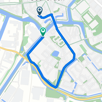
A cycling route starting in Coevorden, Drenthe, The Netherlands.
Overview
About this route
Coevorden via UCT to lock De Haandrik (flood areas on the NL side), then continue via kw-VtR, but also UCT (old arms) to Laar, at the windmill Laar indication of a new cycling path on the northern Vechte dike (flood basin), continue via Agterhorn to the new crank ferry, then via Echteler back to the Vechte (kw-VtR, UCT) into Emlichheim (baptismal font ref. church, House Ringerbrüggen, top), then out to the kw-VtR/UCT over cyclist bridge to Ringe, lunch at 'Altes Landhaus Buddenberg', exhibition 'Living and Working in the Moor'. Via UCT to the Coevorden-Piccardie Canal, kw-objects at the canal and continue to Neugnadenfeld, then via UCT north to Nieuw-Schoonebeek, along Barger Veens, viewpoint, and from there back to Twist, ending at the hotel-restaurant 'Gasthof Backers'.
- -:--
- Duration
- 46.6 km
- Distance
- 28 m
- Ascent
- 26 m
- Descent
- ---
- Avg. speed
- ---
- Max. altitude
Route quality
Waytypes & surfaces along the route
Waytypes
Quiet road
25.6 km
(55 %)
Path
9.3 km
(20 %)
Surfaces
Paved
21.4 km
(46 %)
Unpaved
1.9 km
(4 %)
Asphalt
19.6 km
(42 %)
Paved (undefined)
0.9 km
(2 %)
Continue with Bikemap
Use, edit, or download this cycling route
You would like to ride Journalistenreise 5.-7.07.13 Variante 1 or customize it for your own trip? Here is what you can do with this Bikemap route:
Free features
- Save this route as favorite or in collections
- Copy & plan your own version of this route
- Sync your route with Garmin or Wahoo
Premium features
Free trial for 3 days, or one-time payment. More about Bikemap Premium.
- Navigate this route on iOS & Android
- Export a GPX / KML file of this route
- Create your custom printout (try it for free)
- Download this route for offline navigation
Discover more Premium features.
Get Bikemap PremiumFrom our community
Other popular routes starting in Coevorden
 Rondje Drenthe 2e deel
- Distance
- 143.3 km
- Ascent
- 47 m
- Descent
- 60 m
- Location
- Coevorden, Drenthe, The Netherlands
 LangsDeDrentseGrenzen 306 km
- Distance
- 306.1 km
- Ascent
- 256 m
- Descent
- 254 m
- Location
- Coevorden, Drenthe, The Netherlands
 Spoorhavenstraat 23, Coevorden do Gramsbergerstraat 47, Coevorden
- Distance
- 2 km
- Ascent
- 0 m
- Descent
- 0 m
- Location
- Coevorden, Drenthe, The Netherlands
 Coevorden - Bad Bentheim
- Distance
- 75 km
- Ascent
- 148 m
- Descent
- 91 m
- Location
- Coevorden, Drenthe, The Netherlands
 Coevorden to Werlte
- Distance
- 78.8 km
- Ascent
- 188 m
- Descent
- 163 m
- Location
- Coevorden, Drenthe, The Netherlands
 Grensfietsen.NL - Etappe 3 (Overijssel-Noord) - B-route - Grensfietsen.NL - Etappe 3 (Overijssel-Noord) - B-route
- Distance
- 105.3 km
- Ascent
- 88 m
- Descent
- 75 m
- Location
- Coevorden, Drenthe, The Netherlands
 Fietserpad 4
- Distance
- 135.4 km
- Ascent
- 75 m
- Descent
- 81 m
- Location
- Coevorden, Drenthe, The Netherlands
 RN Dag 6
- Distance
- 53.4 km
- Ascent
- 83 m
- Descent
- 76 m
- Location
- Coevorden, Drenthe, The Netherlands
Open it in the app