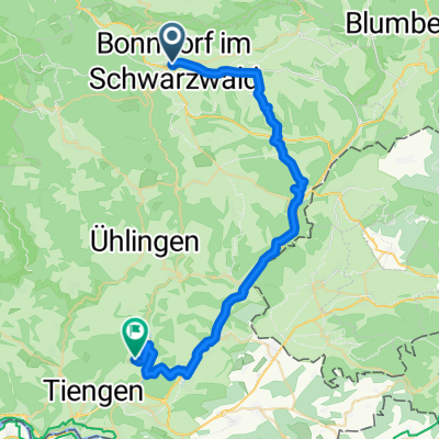
Bonndorf - ZÁVĚR
A cycling route starting in Bonndorf im Schwarzwald, Baden-Württemberg, Germany.
Overview
About this route
Návrh trasy
Poslední den k rýnským vodopádům, pak busem domů. Trasa vede co nejvíce po cyklostezkách Dojezd na bus parkoviště na ulici Nohlstrasse (nad vodopádem) na souř.: <h2 style="margin: 0px; padding: 0px; font-size: 18px; cursor: pointer; color: #000000; font-family: arial, sans-serif;"> 47°40'40.890"N 8°36'35.629"E</h2>
(cloned from route 1909979)- -:--
- Duration
- 41.6 km
- Distance
- 254 m
- Ascent
- 725 m
- Descent
- ---
- Avg. speed
- ---
- Avg. speed
Route quality
Waytypes & surfaces along the route
Waytypes
Quiet road
11.8 km
(28 %)
Track
10.1 km
(24 %)
Surfaces
Paved
30.6 km
(73 %)
Unpaved
3.2 km
(8 %)
Asphalt
25.5 km
(61 %)
Concrete
2.7 km
(6 %)
Continue with Bikemap
Use, edit, or download this cycling route
You would like to ride Bonndorf - ZÁVĚR or customize it for your own trip? Here is what you can do with this Bikemap route:
Free features
- Save this route as favorite or in collections
- Copy & plan your own version of this route
- Sync your route with Garmin or Wahoo
Premium features
Free trial for 3 days, or one-time payment. More about Bikemap Premium.
- Navigate this route on iOS & Android
- Export a GPX / KML file of this route
- Create your custom printout (try it for free)
- Download this route for offline navigation
Discover more Premium features.
Get Bikemap PremiumFrom our community
Other popular routes starting in Bonndorf im Schwarzwald
- Auf dem Bähnleweg mit Adrian und Karin
- Distance
- 31.5 km
- Ascent
- 209 m
- Descent
- 225 m
- Location
- Bonndorf im Schwarzwald, Baden-Württemberg, Germany
- Wellendingen - Badeparadies Schwarzwald - Schluchsee - Wellendingen
- Distance
- 69.8 km
- Ascent
- 759 m
- Descent
- 759 m
- Location
- Bonndorf im Schwarzwald, Baden-Württemberg, Germany
- Bonndorf - Dillendorf- Boll
- Distance
- 22.4 km
- Ascent
- 518 m
- Descent
- 529 m
- Location
- Bonndorf im Schwarzwald, Baden-Württemberg, Germany
- Gemütliche Route in Bonndorf im Schwarzwald
- Distance
- 12.8 km
- Ascent
- 269 m
- Descent
- 272 m
- Location
- Bonndorf im Schwarzwald, Baden-Württemberg, Germany
- SRW - Bonndorf - Bad Säckingen
- Distance
- 77 km
- Ascent
- 105 m
- Descent
- 679 m
- Location
- Bonndorf im Schwarzwald, Baden-Württemberg, Germany
- Schluchtensteig Etappe 3 von der Schattenmühle nach Fischbach-Schluchsee
- Distance
- 18.2 km
- Ascent
- 882 m
- Descent
- 495 m
- Location
- Bonndorf im Schwarzwald, Baden-Württemberg, Germany
- Fröhnd_Do_Wandern_Wutachschlucht
- Distance
- 12.3 km
- Ascent
- 302 m
- Descent
- 310 m
- Location
- Bonndorf im Schwarzwald, Baden-Württemberg, Germany
- Rundfahrt Bonndorf
- Distance
- 19.8 km
- Ascent
- 257 m
- Descent
- 257 m
- Location
- Bonndorf im Schwarzwald, Baden-Württemberg, Germany
Open it in the app