

Penk
A cycling route starting in Pernitz, Lower Austria, Austria.
Overview
About this route
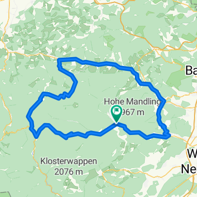
Pernitz-Puchberg-Glocknitz-Penk-Warth-Hochwolkersdorf-Pernitz
(cloned from route 2200002)- -:--
- Duration
- 134.4 km
- Distance
- 1,498 m
- Ascent
- 1,498 m
- Descent
- ---
- Avg. speed
- ---
- Max. altitude
Route quality
Waytypes & surfaces along the route
Waytypes
Road
32.3 km
(24 %)
Quiet road
16.1 km
(12 %)
Surfaces
Paved
82 km
(61 %)
Unpaved
2.7 km
(2 %)
Asphalt
78 km
(58 %)
Paved (undefined)
4 km
(3 %)
Continue with Bikemap
Use, edit, or download this cycling route
You would like to ride Penk or customize it for your own trip? Here is what you can do with this Bikemap route:
Free features
- Save this route as favorite or in collections
- Copy & plan your own version of this route
- Split it into stages to create a multi-day tour
- Sync your route with Garmin or Wahoo
Premium features
Free trial for 3 days, or one-time payment. More about Bikemap Premium.
- Navigate this route on iOS & Android
- Export a GPX / KML file of this route
- Create your custom printout (try it for free)
- Download this route for offline navigation
Discover more Premium features.
Get Bikemap PremiumFrom our community
Other popular routes starting in Pernitz
 Ochsenheid
- Distance
- 13.4 km
- Ascent
- 260 m
- Descent
- 261 m
- Location
- Pernitz, Lower Austria, Austria
 Unterberg Runde
- Distance
- 117.8 km
- Ascent
- 1,093 m
- Descent
- 1,093 m
- Location
- Pernitz, Lower Austria, Austria
 Secrets of Lower Austra
- Distance
- 96.3 km
- Ascent
- 1,233 m
- Descent
- 1,233 m
- Location
- Pernitz, Lower Austria, Austria
 Ochsattel +2
- Distance
- 76 km
- Ascent
- 779 m
- Descent
- 776 m
- Location
- Pernitz, Lower Austria, Austria
 24.07.2022
- Distance
- 41.3 km
- Ascent
- 859 m
- Descent
- 858 m
- Location
- Pernitz, Lower Austria, Austria
 Pernitz-Klostertal-Reichenau-Gloggnitz-Ternitz-Puchberg/Schneeberg-Pernitz
- Distance
- 97.6 km
- Ascent
- 697 m
- Descent
- 699 m
- Location
- Pernitz, Lower Austria, Austria
 Trafl-Unterberg-Kieneck Runde
- Distance
- 30 km
- Ascent
- 1,113 m
- Descent
- 1,113 m
- Location
- Pernitz, Lower Austria, Austria
 #12 - nach 2 Verletzungen
- Distance
- 46.4 km
- Ascent
- 566 m
- Descent
- 569 m
- Location
- Pernitz, Lower Austria, Austria
Open it in the app