

Kl. Wander-Runde Moritzburg ( 2)
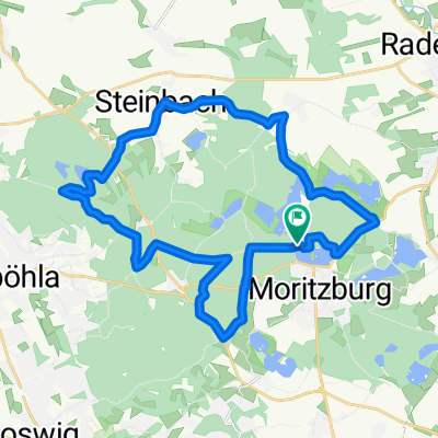
A cycling route starting in Moritzburg, Saxony, Germany.
Overview
About this route
<p><em>Short walk</em></p>
<p>Start at <strong>Moritzburg Station</strong> - Dardanellenweg to the <strong>Lighthouse</strong> - from the Fasanenschlösschen westward along the canal to the "canal bend" - there turn right to Radeburger St. - cross it and follow forest paths to Hellhaus - continue to the <strong>Cafe Seeblick</strong> - back to Kalkreuther St. and then through the Moritzburg Forest to the castle park and the <strong>Castle Island</strong> - the castle avenue southwards to the <strong>Ice Cream Cafe</strong> - turn left into Bahnhofstr. to the <strong>Station</strong>/ starting point</p>
Translated, show original (German)- -:--
- Duration
- 9.6 km
- Distance
- 76 m
- Ascent
- 78 m
- Descent
- ---
- Avg. speed
- ---
- Max. altitude

Route quality
Waytypes & surfaces along the route
Waytypes
Track
4.8 km
(50 %)
Quiet road
1.7 km
(18 %)
Surfaces
Paved
3.3 km
(34 %)
Unpaved
5.4 km
(56 %)
Asphalt
3.3 km
(34 %)
Gravel
2.7 km
(28 %)
Continue with Bikemap
Use, edit, or download this cycling route
You would like to ride Kl. Wander-Runde Moritzburg ( 2) or customize it for your own trip? Here is what you can do with this Bikemap route:
Free features
- Save this route as favorite or in collections
- Copy & plan your own version of this route
- Sync your route with Garmin or Wahoo
Premium features
Free trial for 3 days, or one-time payment. More about Bikemap Premium.
- Navigate this route on iOS & Android
- Export a GPX / KML file of this route
- Create your custom printout (try it for free)
- Download this route for offline navigation
Discover more Premium features.
Get Bikemap PremiumFrom our community
Other popular routes starting in Moritzburg
 Brücke-Tour Moritzbg
- Distance
- 17.4 km
- Ascent
- 97 m
- Descent
- 98 m
- Location
- Moritzburg, Saxony, Germany
 Lesy kolem Moritzburgu
- Distance
- 27 km
- Ascent
- 137 m
- Descent
- 137 m
- Location
- Moritzburg, Saxony, Germany
 10.07.22 Moritzburg-Neschwitz (11. Etappe)
- Distance
- 76.1 km
- Ascent
- 355 m
- Descent
- 377 m
- Location
- Moritzburg, Saxony, Germany
 Kl. Wander-Runde Moritzburg ( 2)
- Distance
- 9.6 km
- Ascent
- 76 m
- Descent
- 78 m
- Location
- Moritzburg, Saxony, Germany
 Moritzburg - Dresden
- Distance
- 26.8 km
- Ascent
- 120 m
- Descent
- 177 m
- Location
- Moritzburg, Saxony, Germany
 Moritzburger Ring abgekürzt
- Distance
- 27.1 km
- Ascent
- 154 m
- Descent
- 153 m
- Location
- Moritzburg, Saxony, Germany
 Flèche Allemagne 2008
- Distance
- 369.7 km
- Ascent
- 3,474 m
- Descent
- 3,350 m
- Location
- Moritzburg, Saxony, Germany
 Dresden (Nord) Keulenberg Dresden (Nord)
- Distance
- 75.4 km
- Ascent
- 398 m
- Descent
- 399 m
- Location
- Moritzburg, Saxony, Germany
Open it in the app