

Massif des Maures vanaf figanieres tot st maxime
A cycling route starting in Figanières, Provence-Alpes-Côte d'Azur Region, France.
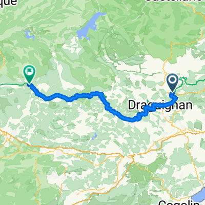
Overview
About this route
Rocher de Roquebrune - Col de Valdingarde - Col du gratteloup - Col du Vignon - roches blanches - col des fourches - col de taillade - grimaud
- -:--
- Duration
- 90.1 km
- Distance
- 793 m
- Ascent
- 1,048 m
- Descent
- ---
- Avg. speed
- ---
- Max. altitude
Route quality
Waytypes & surfaces along the route
Waytypes
Quiet road
18.9 km
(21 %)
Road
10.8 km
(12 %)
Surfaces
Paved
85.6 km
(95 %)
Asphalt
85.6 km
(95 %)
Undefined
4.5 km
(5 %)
Continue with Bikemap
Use, edit, or download this cycling route
You would like to ride Massif des Maures vanaf figanieres tot st maxime or customize it for your own trip? Here is what you can do with this Bikemap route:
Free features
- Save this route as favorite or in collections
- Copy & plan your own version of this route
- Split it into stages to create a multi-day tour
- Sync your route with Garmin or Wahoo
Premium features
Free trial for 3 days, or one-time payment. More about Bikemap Premium.
- Navigate this route on iOS & Android
- Export a GPX / KML file of this route
- Create your custom printout (try it for free)
- Download this route for offline navigation
Discover more Premium features.
Get Bikemap PremiumFrom our community
Other popular routes starting in Figanières
 GORGES DE CHATEAUDOUBLE
- Distance
- 28.7 km
- Ascent
- 928 m
- Descent
- 865 m
- Location
- Figanières, Provence-Alpes-Côte d'Azur Region, France
 Figanieres - sainte maxime plan B
- Distance
- 64.2 km
- Ascent
- 549 m
- Descent
- 817 m
- Location
- Figanières, Provence-Alpes-Côte d'Azur Region, France
 23/07/2014
- Distance
- 63.1 km
- Ascent
- 974 m
- Descent
- 977 m
- Location
- Figanières, Provence-Alpes-Côte d'Azur Region, France
 figa bargemon mons comps figa
- Distance
- 103.9 km
- Ascent
- 1,580 m
- Descent
- 1,581 m
- Location
- Figanières, Provence-Alpes-Côte d'Azur Region, France
 D54 8723, Figanières to Chemin des Aires 70, Pontevès
- Distance
- 59.1 km
- Ascent
- 1,041 m
- Descent
- 917 m
- Location
- Figanières, Provence-Alpes-Côte d'Azur Region, France
 Figanières - Barjols
- Distance
- 70.4 km
- Ascent
- 1,266 m
- Descent
- 1,245 m
- Location
- Figanières, Provence-Alpes-Côte d'Azur Region, France
 figaniers - col bel homme lus
- Distance
- 61.1 km
- Ascent
- 996 m
- Descent
- 995 m
- Location
- Figanières, Provence-Alpes-Côte d'Azur Region, France
 83 C Figabike 2019 + Secrete 36K
- Distance
- 35.7 km
- Ascent
- 1,174 m
- Descent
- 1,173 m
- Location
- Figanières, Provence-Alpes-Côte d'Azur Region, France
Open it in the app