

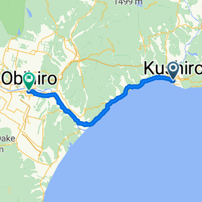
kushiro to obihiro
A cycling route starting in Kushiro, Hokkaido, Japan.
Overview
About this route
from kushiro to obihiro
(cloned from route 2204041)- -:--
- Duration
- 122.2 km
- Distance
- 371 m
- Ascent
- 334 m
- Descent
- ---
- Avg. speed
- ---
- Max. altitude
Route highlights
Points of interest along the route
Point of interest after 7.7 km
vista point
Continue with Bikemap
Use, edit, or download this cycling route
You would like to ride kushiro to obihiro or customize it for your own trip? Here is what you can do with this Bikemap route:
Free features
- Save this route as favorite or in collections
- Copy & plan your own version of this route
- Split it into stages to create a multi-day tour
- Sync your route with Garmin or Wahoo
Premium features
Free trial for 3 days, or one-time payment. More about Bikemap Premium.
- Navigate this route on iOS & Android
- Export a GPX / KML file of this route
- Create your custom printout (try it for free)
- Download this route for offline navigation
Discover more Premium features.
Get Bikemap PremiumFrom our community
Other popular routes starting in Kushiro
 kushiro to obihiro
- Distance
- 122.2 km
- Ascent
- 371 m
- Descent
- 334 m
- Location
- Kushiro, Hokkaido, Japan
 D14-達古武湖畔屈斜路和琴
- Distance
- 108.9 km
- Ascent
- 837 m
- Descent
- 707 m
- Location
- Kushiro, Hokkaido, Japan
 北海道 Day13 釧路to帶廣
- Distance
- 135.9 km
- Ascent
- 268 m
- Descent
- 234 m
- Location
- Kushiro, Hokkaido, Japan
 北海道自転車ツーリング2012夏
- Distance
- 1,039.1 km
- Ascent
- 1,023 m
- Descent
- 1,001 m
- Location
- Kushiro, Hokkaido, Japan
 北海道 Day10 釧路to帶廣
- Distance
- 134.7 km
- Ascent
- 279 m
- Descent
- 251 m
- Location
- Kushiro, Hokkaido, Japan
 環釧路溼原
環釧路溼原- Distance
- 75.6 km
- Ascent
- 557 m
- Descent
- 554 m
- Location
- Kushiro, Hokkaido, Japan
 hokkaido20100812
- Distance
- 126.3 km
- Ascent
- 342 m
- Descent
- 309 m
- Location
- Kushiro, Hokkaido, Japan
 一般道道釧路阿寒自転車道線(釧路阿寒自転車道)
- Distance
- 25.6 km
- Ascent
- 72 m
- Descent
- 47 m
- Location
- Kushiro, Hokkaido, Japan
Open it in the app