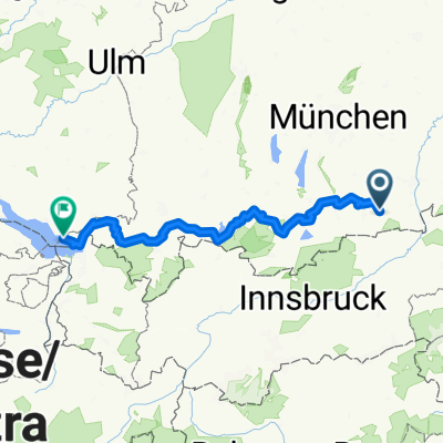
Wörnsmühle Auerberg Rundtour
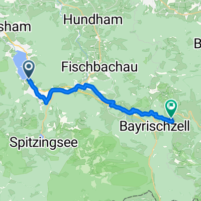
A cycling route starting in Schliersee, Bavaria, Germany.
Overview
About this route
Die Tour ist eine Rundtour und es kann an jeder Stelle eingestiegen werden. Im Folgenden wird der Start-/Zielpunkt auf Wörnsmühle gesetzt. Das erste Stück folgt der Leizach flussaufwärts, entlang der Beschilderung W 2a. Nach einem kurzen Anstieg biegt man links ab und folgt dem Weg nach Achau. Dort verlässt die Strecke die Leizach und steigt nach Ahrein. Über offene Felder kommt man nach Hundham wo man die Hauptstraße überquert und auf der Schwarzenbergstraße den Weg Richtung Deisenried einschlägt. Auf der Höhe von Hub überquert man die Feilenbachenstraße und erklimmt die Steigung zum Gasthof Hocheck. Nach einer optionalen Einkehr folgt man den Straßenverlauf abwärts. Bei einer engen Linkskurve verlässt man die Straße geradeaus und kommt über einen kurzen Trail zu einer Kapelle. Diese lässt man links liegen und folgt dem Weg bis zu einer Kreuzung. Man fährt links in Richtung Brettschleipfn und folgt ab hier der Strecke des „Bodensee – Königssee“ Radweges, der gut Beschildert ist. Dieser führt einen durch Niklasreuth und Sonnenreuth zurück zum Ausgangspunkt nach Wörnsmühle
- -:--
- Duration
- 18.5 km
- Distance
- 478 m
- Ascent
- 478 m
- Descent
- ---
- Avg. speed
- ---
- Avg. speed
Route quality
Waytypes & surfaces along the route
Waytypes
Quiet road
9.5 km
(51 %)
Track
4.4 km
(24 %)
Surfaces
Paved
11.9 km
(65 %)
Unpaved
5 km
(27 %)
Asphalt
11.8 km
(64 %)
Gravel
3.3 km
(18 %)
Route highlights
Points of interest along the route
Point of interest after 9.2 km
Gasthaus Hocheck
Point of interest after 10.7 km
Aussichtskapelle
Continue with Bikemap
Use, edit, or download this cycling route
You would like to ride Wörnsmühle Auerberg Rundtour or customize it for your own trip? Here is what you can do with this Bikemap route:
Free features
- Save this route as favorite or in collections
- Copy & plan your own version of this route
- Sync your route with Garmin or Wahoo
Premium features
Free trial for 3 days, or one-time payment. More about Bikemap Premium.
- Navigate this route on iOS & Android
- Export a GPX / KML file of this route
- Create your custom printout (try it for free)
- Download this route for offline navigation
Discover more Premium features.
Get Bikemap PremiumFrom our community
Other popular routes starting in Schliersee
- Let's kill the Hill
- Distance
- 136.6 km
- Ascent
- 1,317 m
- Descent
- 1,316 m
- Location
- Schliersee, Bavaria, Germany
- Dreiseenrunde Schliersee-Tegernsee-Spitzingsee
- Distance
- 52.3 km
- Ascent
- 771 m
- Descent
- 765 m
- Location
- Schliersee, Bavaria, Germany
- Schliersee - Tegernsee
- Distance
- 23.2 km
- Ascent
- 925 m
- Descent
- 925 m
- Location
- Schliersee, Bavaria, Germany
- Valepprunde
- Distance
- 44.9 km
- Ascent
- 1,034 m
- Descent
- 1,031 m
- Location
- Schliersee, Bavaria, Germany
- Schliersee Tegernsee Rundfahrt
- Distance
- 54.2 km
- Ascent
- 364 m
- Descent
- 364 m
- Location
- Schliersee, Bavaria, Germany
- Von Tegernsee bis Hausham
- Distance
- 55.1 km
- Ascent
- 1,307 m
- Descent
- 1,310 m
- Location
- Schliersee, Bavaria, Germany
- Schliersee südliche Runde über Spitzingsee
- Distance
- 14.4 km
- Ascent
- 637 m
- Descent
- 634 m
- Location
- Schliersee, Bavaria, Germany
- Triathlonstrecke Hexal Alpentriathlon
- Distance
- 40 km
- Ascent
- 817 m
- Descent
- 491 m
- Location
- Schliersee, Bavaria, Germany
Open it in the app