

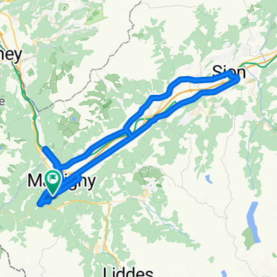
Tour de France 2009, Etappe 16 - 159,0 km
A cycling route starting in Martigny-Combe, Valais, Switzerland.
Overview
About this route
Cloned from:
<span style="color: #000000; font-family: Helvetica; font-size: 12px;">http://www.bikemap.net/route/214684</span>
- -:--
- Duration
- 158.8 km
- Distance
- 4,155 m
- Ascent
- 3,153 m
- Descent
- ---
- Avg. speed
- 2,473 m
- Max. altitude

Route quality
Waytypes & surfaces along the route
Waytypes
Busy road
123.1 km
(77 %)
Road
14.4 km
(9 %)
Surfaces
Paved
115 km
(72 %)
Unpaved
2.1 km
(1 %)
Asphalt
114.2 km
(72 %)
Paving stones
0.7 km
(<1 %)
Continue with Bikemap
Use, edit, or download this cycling route
You would like to ride Tour de France 2009, Etappe 16 - 159,0 km or customize it for your own trip? Here is what you can do with this Bikemap route:
Free features
- Save this route as favorite or in collections
- Copy & plan your own version of this route
- Split it into stages to create a multi-day tour
- Sync your route with Garmin or Wahoo
Premium features
Free trial for 3 days, or one-time payment. More about Bikemap Premium.
- Navigate this route on iOS & Android
- Export a GPX / KML file of this route
- Create your custom printout (try it for free)
- Download this route for offline navigation
Discover more Premium features.
Get Bikemap PremiumFrom our community
Other popular routes starting in Martigny-Combe
 Tour de France 2009, Etappe 16 - 159,0 km
- Distance
- 158.8 km
- Ascent
- 4,155 m
- Descent
- 3,153 m
- Location
- Martigny-Combe, Valais, Switzerland
 Startup Route des Grandes Alpes
- Distance
- 40 km
- Ascent
- 1,360 m
- Descent
- 834 m
- Location
- Martigny-Combe, Valais, Switzerland
 Trevor - Planche loop up the steep side
- Distance
- 29.2 km
- Ascent
- 931 m
- Descent
- 931 m
- Location
- Martigny-Combe, Valais, Switzerland
 MontBlancTour5Tag
- Distance
- 14 km
- Ascent
- 1,107 m
- Descent
- 935 m
- Location
- Martigny-Combe, Valais, Switzerland
 Champex and Val Ferret
- Distance
- 62.9 km
- Ascent
- 1,722 m
- Descent
- 1,722 m
- Location
- Martigny-Combe, Valais, Switzerland
 2017 ALPS Etapa 7 - Le Grand St Bernanrd
- Distance
- 108.8 km
- Ascent
- 2,888 m
- Descent
- 2,896 m
- Location
- Martigny-Combe, Valais, Switzerland
 Route de la Forclaz, Martigny-Croix nach Chemin du Glacier de Taconnaz, Chamonix-Mont-Blanc
- Distance
- 35.6 km
- Ascent
- 658 m
- Descent
- 964 m
- Location
- Martigny-Combe, Valais, Switzerland
 Trevor Base Route
- Distance
- 93.3 km
- Ascent
- 715 m
- Descent
- 715 m
- Location
- Martigny-Combe, Valais, Switzerland
Open it in the app