

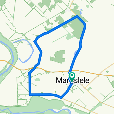
Mártélyi strand
A cycling route starting in Maroslele, Csongrád megye, Hungary.
Overview
About this route
The asphalt was relatively good.
- -:--
- Duration
- 62.5 km
- Distance
- 18 m
- Ascent
- 21 m
- Descent
- ---
- Avg. speed
- ---
- Max. altitude

Route quality
Waytypes & surfaces along the route
Waytypes
Cycleway
22.5 km
(36 %)
Road
5.6 km
(9 %)
Surfaces
Paved
39.4 km
(63 %)
Asphalt
39.4 km
(63 %)
Undefined
23.1 km
(37 %)
Continue with Bikemap
Use, edit, or download this cycling route
You would like to ride Mártélyi strand or customize it for your own trip? Here is what you can do with this Bikemap route:
Free features
- Save this route as favorite or in collections
- Copy & plan your own version of this route
- Sync your route with Garmin or Wahoo
Premium features
Free trial for 3 days, or one-time payment. More about Bikemap Premium.
- Navigate this route on iOS & Android
- Export a GPX / KML file of this route
- Create your custom printout (try it for free)
- Download this route for offline navigation
Discover more Premium features.
Get Bikemap PremiumFrom our community
Other popular routes starting in Maroslele
 Unnamed Road, Óföldeák to Építő utca 5, Szeged
- Distance
- 40 km
- Ascent
- 251 m
- Descent
- 281 m
- Location
- Maroslele, Csongrád megye, Hungary
 Alföldi kiskör
- Distance
- 28 km
- Ascent
- 12 m
- Descent
- 15 m
- Location
- Maroslele, Csongrád megye, Hungary
 Bemelegítés
- Distance
- 33.8 km
- Ascent
- 14 m
- Descent
- 14 m
- Location
- Maroslele, Csongrád megye, Hungary
 Palics kör Fekete József és a Tiszasziget SE Kerékpáros Túra Szakosztály társaságaban
- Distance
- 126.2 km
- Ascent
- 65 m
- Descent
- 63 m
- Location
- Maroslele, Csongrád megye, Hungary
 Mártélyi strand
- Distance
- 62.5 km
- Ascent
- 18 m
- Descent
- 21 m
- Location
- Maroslele, Csongrád megye, Hungary
 Buda kerülés
- Distance
- 450.7 km
- Ascent
- 360 m
- Descent
- 348 m
- Location
- Maroslele, Csongrád megye, Hungary
 Háztól Házig
- Distance
- 15.1 km
- Ascent
- 4 m
- Descent
- 0 m
- Location
- Maroslele, Csongrád megye, Hungary
 sdfsdfsfd
- Distance
- 684 km
- Ascent
- 1,031 m
- Descent
- 1,010 m
- Location
- Maroslele, Csongrád megye, Hungary
Open it in the app