

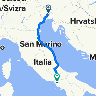
Collio sloveno2 da Mernicco
A cycling route starting in Tavagnacco, Friuli Venezia Giulia, Italy.
Overview
About this route
Very scenic, asphalt in good condition.
- -:--
- Duration
- 84.2 km
- Distance
- 782 m
- Ascent
- 811 m
- Descent
- ---
- Avg. speed
- ---
- Max. altitude

Route quality
Waytypes & surfaces along the route
Waytypes
Road
58.1 km
(69 %)
Quiet road
10.1 km
(12 %)
Surfaces
Paved
46.3 km
(55 %)
Asphalt
46.3 km
(55 %)
Undefined
37.9 km
(45 %)
Continue with Bikemap
Use, edit, or download this cycling route
You would like to ride Collio sloveno2 da Mernicco or customize it for your own trip? Here is what you can do with this Bikemap route:
Free features
- Save this route as favorite or in collections
- Copy & plan your own version of this route
- Split it into stages to create a multi-day tour
- Sync your route with Garmin or Wahoo
Premium features
Free trial for 3 days, or one-time payment. More about Bikemap Premium.
- Navigate this route on iOS & Android
- Export a GPX / KML file of this route
- Create your custom printout (try it for free)
- Download this route for offline navigation
Discover more Premium features.
Get Bikemap PremiumFrom our community
Other popular routes starting in Tavagnacco
 BN_TN_AA_2
- Distance
- 40.8 km
- Ascent
- 292 m
- Descent
- 231 m
- Location
- Tavagnacco, Friuli Venezia Giulia, Italy
 Collio sloveno2 da Mernicco
- Distance
- 84.2 km
- Ascent
- 782 m
- Descent
- 811 m
- Location
- Tavagnacco, Friuli Venezia Giulia, Italy
 Via Giosuè Carducci 49, Tavagnacco a Via Centimolo 71–99, Francolise
- Distance
- 759.8 km
- Ascent
- 2,343 m
- Descent
- 2,423 m
- Location
- Tavagnacco, Friuli Venezia Giulia, Italy
 Lungo il Cornappo, Torre e colline friulane.
- Distance
- 96.5 km
- Ascent
- 1,142 m
- Descent
- 1,144 m
- Location
- Tavagnacco, Friuli Venezia Giulia, Italy
 Udine Izola
- Distance
- 114.6 km
- Ascent
- 703 m
- Descent
- 828 m
- Location
- Tavagnacco, Friuli Venezia Giulia, Italy
 Da Via Michelangelo Buonarroti 53, Feletto Umberto a Via Cividina 38, Magnano In Riviera
- Distance
- 16.4 km
- Ascent
- 219 m
- Descent
- 156 m
- Location
- Tavagnacco, Friuli Venezia Giulia, Italy
 Via della Roggia 1, Tavagnacco a Via Dante Alighieri 93, Tavagnacco
- Distance
- 45.6 km
- Ascent
- 963 m
- Descent
- 966 m
- Location
- Tavagnacco, Friuli Venezia Giulia, Italy
 Udine nach Grado
- Distance
- 55.7 km
- Ascent
- 44 m
- Descent
- 182 m
- Location
- Tavagnacco, Friuli Venezia Giulia, Italy
Open it in the app