

turisticka
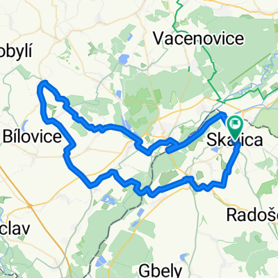
A cycling route starting in Skalica, Trnava Region, Slovakia.
Overview
About this route
- -:--
- Duration
- 190.6 km
- Distance
- 1,232 m
- Ascent
- 1,221 m
- Descent
- ---
- Avg. speed
- 592 m
- Max. altitude
Route quality
Waytypes & surfaces along the route
Waytypes
Quiet road
15.2 km
(8 %)
Road
7.6 km
(4 %)
Surfaces
Paved
137.2 km
(72 %)
Unpaved
1.9 km
(1 %)
Asphalt
135.3 km
(71 %)
Concrete
1.9 km
(1 %)
Route highlights
Points of interest along the route
Point of interest after 59.4 km
šanca doplniť tekutiny a niečo pod zub benzínka slovnaft
Point of interest after 104 km
druha zastavka benzinka slovnaft
Point of interest after 140.5 km
Benzina : kofola 20 kč 2×tatranka 12 kč voda zadarmo
Point of interest after 144.8 km
najvyssie miesto na trase
Continue with Bikemap
Use, edit, or download this cycling route
You would like to ride turisticka or customize it for your own trip? Here is what you can do with this Bikemap route:
Free features
- Save this route as favorite or in collections
- Copy & plan your own version of this route
- Split it into stages to create a multi-day tour
- Sync your route with Garmin or Wahoo
Premium features
Free trial for 3 days, or one-time payment. More about Bikemap Premium.
- Navigate this route on iOS & Android
- Export a GPX / KML file of this route
- Create your custom printout (try it for free)
- Download this route for offline navigation
Discover more Premium features.
Get Bikemap PremiumFrom our community
Other popular routes starting in Skalica
 Skalica - Golfový klub - Prietržka - Trnovec - Holíč - Vrádište - Skalica
- Distance
- 18 km
- Ascent
- 119 m
- Descent
- 122 m
- Location
- Skalica, Trnava Region, Slovakia
 B08 Skalica - Cerova
- Distance
- 66.3 km
- Ascent
- 1,219 m
- Descent
- 1,169 m
- Location
- Skalica, Trnava Region, Slovakia
 Skalica - Golfový klub - Skalické rybníky - Skalica
- Distance
- 9 km
- Ascent
- 38 m
- Descent
- 41 m
- Location
- Skalica, Trnava Region, Slovakia
 Pokojná trasa
- Distance
- 44 km
- Ascent
- 863 m
- Descent
- 872 m
- Location
- Skalica, Trnava Region, Slovakia
 Skalica - Kopčany
- Distance
- 18.3 km
- Ascent
- 43 m
- Descent
- 63 m
- Location
- Skalica, Trnava Region, Slovakia
 Skalica-Holič-Kopčany-Mikulčice-Lužice-Hodonin
- Distance
- 48.8 km
- Ascent
- 184 m
- Descent
- 181 m
- Location
- Skalica, Trnava Region, Slovakia
 turisticka
- Distance
- 190.6 km
- Ascent
- 1,232 m
- Descent
- 1,221 m
- Location
- Skalica, Trnava Region, Slovakia
 SKALICKE BUDY 2025
- Distance
- 74.2 km
- Ascent
- 491 m
- Descent
- 490 m
- Location
- Skalica, Trnava Region, Slovakia
Open it in the app