

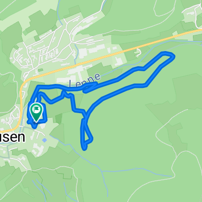
Brachthausen-Ahe-Flape
A cycling route starting in Kirchhundem, North Rhine-Westphalia, Germany.
Overview
About this route
xx
(cloned from route 2207204)- -:--
- Duration
- 20.2 km
- Distance
- 486 m
- Ascent
- 484 m
- Descent
- ---
- Avg. speed
- ---
- Max. altitude
Route quality
Waytypes & surfaces along the route
Waytypes
Track
16.1 km
(80 %)
Quiet road
3.8 km
(19 %)
Access road
0.2 km
(1 %)
Surfaces
Paved
2 km
(10 %)
Unpaved
15.5 km
(77 %)
Gravel
6.6 km
(33 %)
Ground
5 km
(25 %)
Route highlights
Points of interest along the route
Point of interest after 12.6 km
Kirche
Continue with Bikemap
Use, edit, or download this cycling route
You would like to ride Brachthausen-Ahe-Flape or customize it for your own trip? Here is what you can do with this Bikemap route:
Free features
- Save this route as favorite or in collections
- Copy & plan your own version of this route
- Sync your route with Garmin or Wahoo
Premium features
Free trial for 3 days, or one-time payment. More about Bikemap Premium.
- Navigate this route on iOS & Android
- Export a GPX / KML file of this route
- Create your custom printout (try it for free)
- Download this route for offline navigation
Discover more Premium features.
Get Bikemap PremiumFrom our community
Other popular routes starting in Kirchhundem
 Kirchhundemer Land 1
- Distance
- 21.3 km
- Ascent
- 316 m
- Descent
- 281 m
- Location
- Kirchhundem, North Rhine-Westphalia, Germany
 Schmallenberg1
- Distance
- 34.6 km
- Ascent
- 588 m
- Descent
- 584 m
- Location
- Kirchhundem, North Rhine-Westphalia, Germany
 Rundfahrt zum Drachenfest auf dem Franzosenkopf
- Distance
- 63.4 km
- Ascent
- 733 m
- Descent
- 786 m
- Location
- Kirchhundem, North Rhine-Westphalia, Germany
 Rothaarsteig-Spur Oberhundemer Bergtour
- Distance
- 11.6 km
- Ascent
- 419 m
- Descent
- 419 m
- Location
- Kirchhundem, North Rhine-Westphalia, Germany
 2.Tag Saalhausen-Winterberg
- Distance
- 40.6 km
- Ascent
- 823 m
- Descent
- 480 m
- Location
- Kirchhundem, North Rhine-Westphalia, Germany
 MTB Bundesliegastrecke Saalhausen CLONED FROM ROUTE 1107955
- Distance
- 4.1 km
- Ascent
- 219 m
- Descent
- 219 m
- Location
- Kirchhundem, North Rhine-Westphalia, Germany
 Kurze Ausfahrt durch Lennestadt
- Distance
- 9.1 km
- Ascent
- 226 m
- Descent
- 231 m
- Location
- Kirchhundem, North Rhine-Westphalia, Germany
 waldrunde mittel
- Distance
- 5 km
- Ascent
- 262 m
- Descent
- 262 m
- Location
- Kirchhundem, North Rhine-Westphalia, Germany
Open it in the app