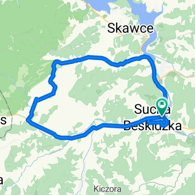
trasa nr 1 na Ja艂owiec (1111 mnp)
A cycling route starting in Sucha Beskidzka, Lesser Poland Voivodeship, Poland.
Overview
About this route
Trasa g贸rska, w wi臋kszo艣ci w terenie. Powr贸t z Siwc贸wki do Suchej Beskidzkiej szos膮, ale mam ju偶 opracowan膮 tras臋 przez Wojewodow膮 g贸r臋, gdzie ko艅c贸wka po szosie b臋dzie dw贸krotnie kr贸tsza. Wrzuc臋 jak tylko sprawdz臋 przejazd osobi艣cie.
Po drodze zaliczamy dwa szczyty, pierwszy to Mag贸rka 872 mnp, drugi to Ja艂owiec 1111 mnp.
Najfajniejsze zjazdy znajduj膮 si臋 za szczytem ja艂owca, oraz po przejechaniu osiedla Wsi贸rz (osiedle to jest na zoboczu g贸ry Solniska 849 mnp, znajduje si臋 na 29 kilometrze trasy, ostry skr臋t w prawo, w d贸艂 zielonym szlakiem)
- -:--
- Duration
- 41.3 km
- Distance
- 1,207 m
- Ascent
- 1,203 m
- Descent
- ---
- Avg. speed
- ---
- Avg. speed
Continue with Bikemap
Use, edit, or download this cycling route
You would like to ride trasa nr 1 na Ja艂owiec (1111 mnp) or customize it for your own trip? Here is what you can do with this Bikemap route:
Free features
- Save this route as favorite or in collections
- Copy & plan your own version of this route
- Sync your route with Garmin or Wahoo
Premium features
Free trial for 3 days, or one-time payment. More about Bikemap Premium.
- Navigate this route on iOS & Android
- Export a GPX / KML file of this route
- Create your custom printout (try it for free)
- Download this route for offline navigation
Discover more Premium features.
Get Bikemap PremiumFrom our community
Other popular routes starting in Sucha Beskidzka
- B艂膮dzonka 208, Sucha Beskidzka do Aleksandra Starze艅skiego 16, Sucha Beskidzka
- Distance
- 0.7 km
- Ascent
- 0 m
- Descent
- 23 m
- Location
- Sucha Beskidzka, Lesser Poland Voivodeship, Poland
- Route to Stryszawa 23C, 34-205 Stryszawa
- Distance
- 188.9 km
- Ascent
- 4,420 m
- Descent
- 4,363 m
- Location
- Sucha Beskidzka, Lesser Poland Voivodeship, Poland
- Z Suchej do Krakowa 19.06.2010
- Distance
- 61.1 km
- Ascent
- 272 m
- Descent
- 416 m
- Location
- Sucha Beskidzka, Lesser Poland Voivodeship, Poland
- sucha Beskidzka
- Distance
- 20.9 km
- Ascent
- 561 m
- Descent
- 558 m
- Location
- Sucha Beskidzka, Lesser Poland Voivodeship, Poland
- Memorialem Henryka 艁asaka
- Distance
- 33.1 km
- Ascent
- 361 m
- Descent
- 350 m
- Location
- Sucha Beskidzka, Lesser Poland Voivodeship, Poland
- 30.08.2015
- Distance
- 129.6 km
- Ascent
- 1,073 m
- Descent
- 1,073 m
- Location
- Sucha Beskidzka, Lesser Poland Voivodeship, Poland
- trasa nr 1 na Ja艂owiec (1111 mnp)
- Distance
- 41.3 km
- Ascent
- 1,207 m
- Descent
- 1,203 m
- Location
- Sucha Beskidzka, Lesser Poland Voivodeship, Poland
- Wok贸艂 Tatr
- Distance
- 310.1 km
- Ascent
- 2,198 m
- Descent
- 2,207 m
- Location
- Sucha Beskidzka, Lesser Poland Voivodeship, Poland
Open it in the app