

Monviso 2013 prima tappa
A cycling route starting in Passirana, Lombardy, Italy.
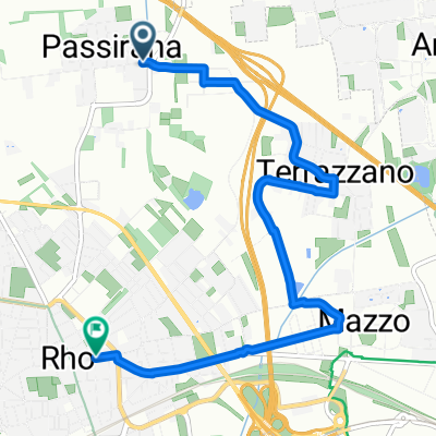
Overview
About this route
First stage from Lainate to Serralunga di Crea
- -:--
- Duration
- 103.2 km
- Distance
- 405 m
- Ascent
- 171 m
- Descent
- ---
- Avg. speed
- ---
- Max. altitude
Route quality
Waytypes & surfaces along the route
Waytypes
Road
57.8 km
(56 %)
Quiet road
8.3 km
(8 %)
Surfaces
Paved
73.3 km
(71 %)
Unpaved
1 km
(1 %)
Asphalt
73.3 km
(71 %)
Unpaved (undefined)
1 km
(1 %)
Undefined
28.9 km
(28 %)
Continue with Bikemap
Use, edit, or download this cycling route
You would like to ride Monviso 2013 prima tappa or customize it for your own trip? Here is what you can do with this Bikemap route:
Free features
- Save this route as favorite or in collections
- Copy & plan your own version of this route
- Split it into stages to create a multi-day tour
- Sync your route with Garmin or Wahoo
Premium features
Free trial for 3 days, or one-time payment. More about Bikemap Premium.
- Navigate this route on iOS & Android
- Export a GPX / KML file of this route
- Create your custom printout (try it for free)
- Download this route for offline navigation
Discover more Premium features.
Get Bikemap PremiumFrom our community
Other popular routes starting in Passirana
 Parco groane
- Distance
- 64.1 km
- Ascent
- 399 m
- Descent
- 404 m
- Location
- Passirana, Lombardy, Italy
 Passirana 1
- Distance
- 36.1 km
- Ascent
- 96 m
- Descent
- 97 m
- Location
- Passirana, Lombardy, Italy
 Arese - Lainate - Castellazzo - arese
- Distance
- 24.2 km
- Ascent
- 74 m
- Descent
- 72 m
- Location
- Passirana, Lombardy, Italy
 Da Via Vincenzo Bellini 32B, Lainate a Piazza Municipio 6, Morimondo
- Distance
- 32 km
- Ascent
- 17 m
- Descent
- 89 m
- Location
- Passirana, Lombardy, Italy
 Da Centro Commerciale Arese A Via Quinto Romano 58
- Distance
- 15.2 km
- Ascent
- 31 m
- Descent
- 83 m
- Location
- Passirana, Lombardy, Italy
 Arese centro comm rho via arese centro
- Distance
- 8.8 km
- Ascent
- 20 m
- Descent
- 43 m
- Location
- Passirana, Lombardy, Italy
 Rho Cucciago
- Distance
- 74.5 km
- Ascent
- 483 m
- Descent
- 483 m
- Location
- Passirana, Lombardy, Italy
 prendiamoci cura urbana
- Distance
- 6.3 km
- Ascent
- 10 m
- Descent
- 18 m
- Location
- Passirana, Lombardy, Italy
Open it in the app