3.GR99 Trespaderne-Haro
A cycling route starting in Trespaderne, Castille and Le贸n, Spain.
Overview
About this route
At the turn-off to Trespaderne (you take it next to the bridge and it takes us to the other side of the road), the path was in very bad condition (this year, due to flooding, it's very common in many sections). For this reason, we decided to descend via a quiet road, went to Fr铆as, and would pick it up again there.
- -:--
- Duration
- 84.9 km
- Distance
- 856 m
- Ascent
- 949 m
- Descent
- ---
- Avg. speed
- ---
- Max. altitude
Route quality
Waytypes & surfaces along the route
Waytypes
Track
30.6 km
(36 %)
Road
14.4 km
(17 %)
Surfaces
Paved
34 km
(40 %)
Unpaved
21.2 km
(25 %)
Asphalt
32.3 km
(38 %)
Gravel
10.2 km
(12 %)
Route highlights
Points of interest along the route
Point of interest after 0.4 km
GRa nahiko txarto zegoen (putzu itzelak pistetan) eta ibai tik aldentzea erabaki genuen, ibai ondoko errepidea jarraituz ia ia Frias ingururaino, ubidea jarraituta.
Point of interest after 13.9 km
GRa ibai ondoko pistatik doa, baina txarto zegoenez, gomendatu ziguten beste aldeko errepide herrikoia erabiltzea, hurrengo egunean bat egiteko GRarekin
Point of interest after 18.6 km
etxe ondoan bideak jarraitzen zuen, baina bidea ez zen ezta ikusten, ezinezkoa zen igartzea handik eta beraz, errepidera joan ginen berriro. Gra arurrerago ere errepidera pasatzen da
Point of interest after 22.5 km
2dea txarto egonda Garo帽arantz joan ginen errepidetik
Point of interest after 52.4 km
errepidera joan ginen
Point of interest after 68.5 km
Autobideko zubi azpitik ez igaro, jarraitu zubiazpitik poligonoraino, poligono zeharkatu ikusten den herrirantz.Ibai ondoko bidea desagertu baita lanekin
Point of interest after 72.3 km
Errioxara errpidetik joatea gomendatu digute, eta merezi du, oso errepide lasaia eta polita da, gaienra zuzena
Continue with Bikemap
Use, edit, or download this cycling route
You would like to ride 3.GR99 Trespaderne-Haro or customize it for your own trip? Here is what you can do with this Bikemap route:
Free features
- Save this route as favorite or in collections
- Copy & plan your own version of this route
- Split it into stages to create a multi-day tour
- Sync your route with Garmin or Wahoo
Premium features
Free trial for 3 days, or one-time payment. More about Bikemap Premium.
- Navigate this route on iOS & Android
- Export a GPX / KML file of this route
- Create your custom printout (try it for free)
- Download this route for offline navigation
Discover more Premium features.
Get Bikemap PremiumFrom our community
Other popular routes starting in Trespaderne
- EBRO 4陋 ETAPA TRESPADERNE-MIRANDA DE EBRO
- Distance
- 47.8 km
- Ascent
- 240 m
- Descent
- 334 m
- Location
- Trespaderne, Castille and Le贸n, Spain
- Trespaderne 2 (64 kms)
- Distance
- 63.5 km
- Ascent
- 1,057 m
- Descent
- 1,058 m
- Location
- Trespaderne, Castille and Le贸n, Spain
- Trespaderne - Noceco
- Distance
- 43.4 km
- Ascent
- 392 m
- Descent
- 137 m
- Location
- Trespaderne, Castille and Le贸n, Spain
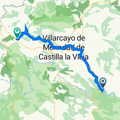
- De Barrio San Pedro 3, Nofuentes a Calle Carretera Laredo 18, Nofuentes
- Distance
- 14.8 km
- Ascent
- 431 m
- Descent
- 449 m
- Location
- Trespaderne, Castille and Le贸n, Spain
- De Traves铆a Bilbao 13, Cadi帽anos a Plaza de San Vicente 16, Trespaderne
- Distance
- 6.4 km
- Ascent
- 48 m
- Descent
- 51 m
- Location
- Trespaderne, Castille and Le贸n, Spain
- Trespaderne nach Soncillo
- Distance
- 56.3 km
- Ascent
- 915 m
- Descent
- 621 m
- Location
- Trespaderne, Castille and Le贸n, Spain
- 3.GR99 Trespaderne-Haro
- Distance
- 84.9 km
- Ascent
- 856 m
- Descent
- 949 m
- Location
- Trespaderne, Castille and Le贸n, Spain
- Bilbao to Lisabon (2019) - Day 2
- Distance
- 119.8 km
- Ascent
- 501 m
- Descent
- 290 m
- Location
- Trespaderne, Castille and Le贸n, Spain
Open it in the app