

Pohorska kolesarska transverzala (PT)
A cycling route starting in Legen, Slovenj Gradec, Slovenia.
Overview
About this route
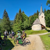
Along the southern slopes of Pohorje runs a cycling path that connects the eastern part with the western part. Local cycling paths from all major towns around Pohorje intersect this transversal. In the Koroška region, the starting point for this 75 km long undulating tour, which is marked in both directions (sign PT), is at the Hut below Mount Kremžar above Slovenj Gradec. The end of the route (or the start from the opposite direction) is at the Center for Natural and Cultural Heritage in Bolfenk on Pohorje or at the lower station of the Pohorje cable car above Maribor.
Pohorje is a mountain range in northeastern Slovenia. The peculiarity of Pohorje is the characteristic view of the dark green of the coniferous forests. In the forested areas of Pohorje, the forests are deep and dark; here and there almost impenetrable. Conifers predominantly prevail in them. On Ribniško Pohorje, the Sgerm spruce grows, which at a height of 61.8 m is the tallest tree in Central Europe.
- -:--
- Duration
- 73.3 km
- Distance
- 1,461 m
- Ascent
- 1,520 m
- Descent
- ---
- Avg. speed
- ---
- Max. altitude

Route quality
Waytypes & surfaces along the route
Waytypes
Track
52.7 km
(72 %)
Quiet road
12.5 km
(17 %)
Road
8.1 km
(11 %)
Surfaces
Paved
15.4 km
(21 %)
Unpaved
56.4 km
(77 %)
Gravel
41.8 km
(57 %)
Paved (undefined)
14.7 km
(20 %)
Continue with Bikemap
Use, edit, or download this cycling route
You would like to ride Pohorska kolesarska transverzala (PT) or customize it for your own trip? Here is what you can do with this Bikemap route:
Free features
- Save this route as favorite or in collections
- Copy & plan your own version of this route
- Sync your route with Garmin or Wahoo
Premium features
Free trial for 3 days, or one-time payment. More about Bikemap Premium.
- Navigate this route on iOS & Android
- Export a GPX / KML file of this route
- Create your custom printout (try it for free)
- Download this route for offline navigation
Discover more Premium features.
Get Bikemap PremiumFrom our community
Other popular routes starting in Legen
 Mačkov Križ - Kope
- Distance
- 13.6 km
- Ascent
- 201 m
- Descent
- 574 m
- Location
- Legen, Slovenj Gradec, Slovenia
 Kope Pahersko Pesnik Ribniško jezero Kope
- Distance
- 36.1 km
- Ascent
- 1,125 m
- Descent
- 1,119 m
- Location
- Legen, Slovenj Gradec, Slovenia
 Pohorska kolesarska transverzala (PT)
- Distance
- 73.3 km
- Ascent
- 1,461 m
- Descent
- 1,520 m
- Location
- Legen, Slovenj Gradec, Slovenia
 Hudi Kot, Ribnica na Pohorju nach Razborca 66, Mislinja
- Distance
- 13.8 km
- Ascent
- 902 m
- Descent
- 913 m
- Location
- Legen, Slovenj Gradec, Slovenia
 Pohorska kolesarska transverzala (PT)
- Distance
- 73.3 km
- Ascent
- 1,461 m
- Descent
- 1,520 m
- Location
- Legen, Slovenj Gradec, Slovenia
 Pohorska kolesarska transverzala (PT)
- Distance
- 73.3 km
- Ascent
- 1,442 m
- Descent
- 1,495 m
- Location
- Legen, Slovenj Gradec, Slovenia
 Kope-Rogla pp
- Distance
- 15.7 km
- Ascent
- 562 m
- Descent
- 438 m
- Location
- Legen, Slovenj Gradec, Slovenia
 Legen 161, Slovenj Gradec nach Kajuhova ulica 14, Slovenj Gradec
- Distance
- 30.3 km
- Ascent
- 1,184 m
- Descent
- 1,391 m
- Location
- Legen, Slovenj Gradec, Slovenia
Open it in the app