

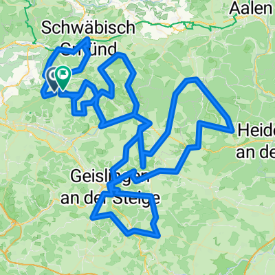
Albextrem 2013 - 260 km
A cycling route starting in Ottenbach, Baden-Wurttemberg, Germany.
Overview
About this route
-
Albextrem 2013 - 260er-Runde
Durch Sperrung der Neidlinger Steige Umleitung über Schopfloch - Hepsisau
- -:--
- Duration
- 265.1 km
- Distance
- 2,766 m
- Ascent
- 2,779 m
- Descent
- ---
- Avg. speed
- ---
- Max. altitude

Route quality
Waytypes & surfaces along the route
Waytypes
Road
111.3 km
(42 %)
Quiet road
39.8 km
(15 %)
Surfaces
Paved
201.5 km
(76 %)
Asphalt
196.2 km
(74 %)
Paved (undefined)
5.3 km
(2 %)
Undefined
63.6 km
(24 %)
Route highlights
Points of interest along the route
Point of interest after 0 km
Start
Point of interest after 16.1 km
1. Kontrollstelle Marktplatz Schwäbisch-Gmünd
Point of interest after 41.4 km
Sonderkontrolle Tannweiler
Point of interest after 46.6 km
Verpflegungsstelle im Hof der Firmat Leicht
Point of interest after 85.4 km
Verpflegungsstelle Bartholomä
Point of interest after 115.5 km
Kontrollstelle + Fotopoint Waldhausen
Point of interest after 136.4 km
Kontrolle + Verpflegung Hofstett-Emerbuch
Point of interest after 152.3 km
Kontrollstelle Türkheim
Point of interest after 162.9 km
Verpflegungstelle Bad Ditzenbach
Point of interest after 208.4 km
Verpflegung + Kontrolle Kirchplatz Bad Boll
Point of interest after 243.8 km
Kontrolle + Verpflegung Stötten
Point of interest after 265.1 km
Ziel - Sportgelände Im Buchs
Continue with Bikemap
Use, edit, or download this cycling route
You would like to ride Albextrem 2013 - 260 km or customize it for your own trip? Here is what you can do with this Bikemap route:
Free features
- Save this route as favorite or in collections
- Copy & plan your own version of this route
- Split it into stages to create a multi-day tour
- Sync your route with Garmin or Wahoo
Premium features
Free trial for 3 days, or one-time payment. More about Bikemap Premium.
- Navigate this route on iOS & Android
- Export a GPX / KML file of this route
- Create your custom printout (try it for free)
- Download this route for offline navigation
Discover more Premium features.
Get Bikemap PremiumFrom our community
Other popular routes starting in Ottenbach
 Albextrem 220 km
- Distance
- 218.2 km
- Ascent
- 3,735 m
- Descent
- 3,579 m
- Location
- Ottenbach, Baden-Wurttemberg, Germany
 Alb Extrem 2007 - 190 km
- Distance
- 189.2 km
- Ascent
- 2,989 m
- Descent
- 2,852 m
- Location
- Ottenbach, Baden-Wurttemberg, Germany
 Waldschenke härtere Tour
- Distance
- 14.1 km
- Ascent
- 315 m
- Descent
- 368 m
- Location
- Ottenbach, Baden-Wurttemberg, Germany
 Alb Extrem 190
- Distance
- 189.7 km
- Ascent
- 2,899 m
- Descent
- 2,776 m
- Location
- Ottenbach, Baden-Wurttemberg, Germany
 20130630 Alb-Extrem 210km
- Distance
- 207.7 km
- Ascent
- 2,218 m
- Descent
- 2,218 m
- Location
- Ottenbach, Baden-Wurttemberg, Germany
 Albextrem2022 260 km
- Distance
- 257.2 km
- Ascent
- 4,675 m
- Descent
- 4,685 m
- Location
- Ottenbach, Baden-Wurttemberg, Germany
 Alb Extrem 210 km
- Distance
- 203 km
- Ascent
- 2,999 m
- Descent
- 2,845 m
- Location
- Ottenbach, Baden-Wurttemberg, Germany
 Alb Extrem 2008 - 200 km
- Distance
- 195.4 km
- Ascent
- 2,378 m
- Descent
- 2,253 m
- Location
- Ottenbach, Baden-Wurttemberg, Germany
Open it in the app