

Stollberg-Brünlos- Stausee Geyer und zurück
A cycling route starting in Neukirchen, Saxony, Germany.
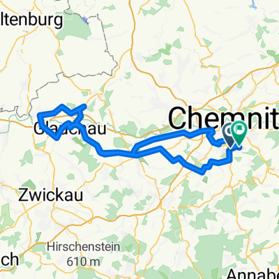
Overview
About this route
Che-Albert Köhlerstr.
Adorf Bahn nach Stollberg Stadtbadklause links neben der S258 alte Stollbergerstr nach Brünlos alte Brünloserstr. nach Dorfchemnitz zwischen den Kuhställen durch bis Kreuzweg nach links Richt.Jugendherberge /Gifthütte Weg weiter bis Geyrische Str. rechts zum Stausee Geyer Rückweg Hormersdorf Gornsdorf Meinersdorf Gasthaus Morgensonne rechts ab nach Adorf Klaffenbach Chemnitz - -:--
- Duration
- 54.8 km
- Distance
- 773 m
- Ascent
- 779 m
- Descent
- ---
- Avg. speed
- ---
- Max. altitude

Route quality
Waytypes & surfaces along the route
Waytypes
Road
21.7 km
(40 %)
Track
12.8 km
(23 %)
Surfaces
Paved
39.7 km
(72 %)
Unpaved
11.9 km
(22 %)
Asphalt
37.3 km
(68 %)
Gravel
8.3 km
(15 %)
Continue with Bikemap
Use, edit, or download this cycling route
You would like to ride Stollberg-Brünlos- Stausee Geyer und zurück or customize it for your own trip? Here is what you can do with this Bikemap route:
Free features
- Save this route as favorite or in collections
- Copy & plan your own version of this route
- Sync your route with Garmin or Wahoo
Premium features
Free trial for 3 days, or one-time payment. More about Bikemap Premium.
- Navigate this route on iOS & Android
- Export a GPX / KML file of this route
- Create your custom printout (try it for free)
- Download this route for offline navigation
Discover more Premium features.
Get Bikemap PremiumFrom our community
Other popular routes starting in Neukirchen
 Neukirchen - Lugau - Neukirchen
- Distance
- 28.1 km
- Ascent
- 197 m
- Descent
- 193 m
- Location
- Neukirchen, Saxony, Germany
 Chemnitz-Keilberg-Fichtelberg-Chemnitz
- Distance
- 119.9 km
- Ascent
- 1,362 m
- Descent
- 1,362 m
- Location
- Neukirchen, Saxony, Germany
 RR Tour Meerane
- Distance
- 99.6 km
- Ascent
- 423 m
- Descent
- 388 m
- Location
- Neukirchen, Saxony, Germany
 Erzgebirgstour
- Distance
- 96.5 km
- Ascent
- 1,517 m
- Descent
- 1,494 m
- Location
- Neukirchen, Saxony, Germany
 Chemnitz - Südböhmen - Südmähren
- Distance
- 844.3 km
- Ascent
- 2,001 m
- Descent
- 2,130 m
- Location
- Neukirchen, Saxony, Germany
 Oberwald Hohenstein querdurch
- Distance
- 42.8 km
- Ascent
- 430 m
- Descent
- 433 m
- Location
- Neukirchen, Saxony, Germany
 Zwönitz
- Distance
- 52.3 km
- Ascent
- 727 m
- Descent
- 723 m
- Location
- Neukirchen, Saxony, Germany
 Lichtenstein über Ursprung
- Distance
- 43 km
- Ascent
- 331 m
- Descent
- 329 m
- Location
- Neukirchen, Saxony, Germany
Open it in the app