
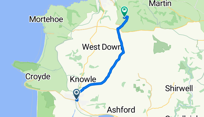
braunton-trail centre
A cycling route starting in Braunton, England, United Kingdom.
Overview
About this route
xc route to keypitts
- -:--
- Duration
- 12.7 km
- Distance
- 288 m
- Ascent
- 124 m
- Descent
- ---
- Avg. speed
- ---
- Max. altitude
Route quality
Waytypes & surfaces along the route
Waytypes
Quiet road
5.8 km
(46 %)
Track
4 km
(31 %)
Surfaces
Paved
0.8 km
(6 %)
Asphalt
0.6 km
(4 %)
Paved (undefined)
0.2 km
(2 %)
Undefined
11.9 km
(94 %)
Continue with Bikemap
Use, edit, or download this cycling route
You would like to ride braunton-trail centre or customize it for your own trip? Here is what you can do with this Bikemap route:
Free features
- Save this route as favorite or in collections
- Copy & plan your own version of this route
- Sync your route with Garmin or Wahoo
Premium features
Free trial for 3 days, or one-time payment. More about Bikemap Premium.
- Navigate this route on iOS & Android
- Export a GPX / KML file of this route
- Create your custom printout (try it for free)
- Download this route for offline navigation
Discover more Premium features.
Get Bikemap PremiumFrom our community
Other popular routes starting in Braunton
 1 st ride out
- Distance
- 18.9 km
- Ascent
- 55 m
- Descent
- 55 m
- Location
- Braunton, England, United Kingdom
 pint and a coffee
- Distance
- 25 km
- Ascent
- 370 m
- Descent
- 367 m
- Location
- Braunton, England, United Kingdom
 braunton to m5
- Distance
- 71.1 km
- Ascent
- 609 m
- Descent
- 528 m
- Location
- Braunton, England, United Kingdom
 braunton-trail centre
- Distance
- 12.7 km
- Ascent
- 288 m
- Descent
- 124 m
- Location
- Braunton, England, United Kingdom
 sunday ride out 2
- Distance
- 21.6 km
- Ascent
- 376 m
- Descent
- 376 m
- Location
- Braunton, England, United Kingdom
 slack jaw
- Distance
- 20.6 km
- Ascent
- 318 m
- Descent
- 318 m
- Location
- Braunton, England, United Kingdom
 Long ride over exmoor
- Distance
- 141 km
- Ascent
- 2,180 m
- Descent
- 2,182 m
- Location
- Braunton, England, United Kingdom
 ride around
- Distance
- 16.2 km
- Ascent
- 146 m
- Descent
- 143 m
- Location
- Braunton, England, United Kingdom
Open it in the app