
Gavet_Rochetaillée_Villard_reculas_Alpe_Huez_Sarenne_voile_mariée_Bourg_Gavet
A cycling route starting in Vaulnaveys-le-Bas, Auvergne-Rhône-Alpes, France.
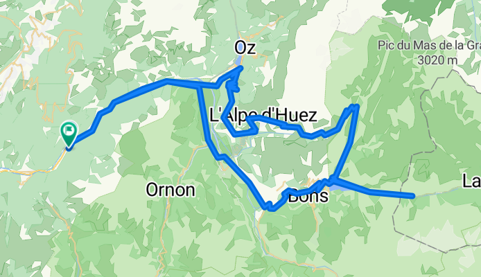
Overview
About this route
for 100 km & 2000 m of elevation difference
- -:--
- Duration
- 103.9 km
- Distance
- 1,844 m
- Ascent
- 1,844 m
- Descent
- ---
- Avg. speed
- ---
- Max. altitude

Route quality
Waytypes & surfaces along the route
Waytypes
Road
21.8 km
(21 %)
Quiet road
11.4 km
(11 %)
Surfaces
Paved
84.1 km
(81 %)
Asphalt
84.1 km
(81 %)
Undefined
19.7 km
(19 %)
Continue with Bikemap
Use, edit, or download this cycling route
You would like to ride Gavet_Rochetaillée_Villard_reculas_Alpe_Huez_Sarenne_voile_mariée_Bourg_Gavet or customize it for your own trip? Here is what you can do with this Bikemap route:
Free features
- Save this route as favorite or in collections
- Copy & plan your own version of this route
- Split it into stages to create a multi-day tour
- Sync your route with Garmin or Wahoo
Premium features
Free trial for 3 days, or one-time payment. More about Bikemap Premium.
- Navigate this route on iOS & Android
- Export a GPX / KML file of this route
- Create your custom printout (try it for free)
- Download this route for offline navigation
Discover more Premium features.
Get Bikemap PremiumFrom our community
Other popular routes starting in Vaulnaveys-le-Bas
 Col de la Madeleine
- Distance
- 9.4 km
- Ascent
- 822 m
- Descent
- 33 m
- Location
- Vaulnaveys-le-Bas, Auvergne-Rhône-Alpes, France
 Groot rondje 2 Alpes
- Distance
- 110.7 km
- Ascent
- 2,344 m
- Descent
- 2,344 m
- Location
- Vaulnaveys-le-Bas, Auvergne-Rhône-Alpes, France
 Alps 2017 - Alpe d'Huez and Col de Sarenne
- Distance
- 107.1 km
- Ascent
- 2,285 m
- Descent
- 2,287 m
- Location
- Vaulnaveys-le-Bas, Auvergne-Rhône-Alpes, France
 Séchilienne - Glandon - Séchilienne
- Distance
- 92.7 km
- Ascent
- 1,659 m
- Descent
- 1,659 m
- Location
- Vaulnaveys-le-Bas, Auvergne-Rhône-Alpes, France
 ALPE D'HUEZ
- Distance
- 134.4 km
- Ascent
- 2,891 m
- Descent
- 2,889 m
- Location
- Vaulnaveys-le-Bas, Auvergne-Rhône-Alpes, France
 Col Luitel. Chamrousse
- Distance
- 57.1 km
- Ascent
- 1,456 m
- Descent
- 1,473 m
- Location
- Vaulnaveys-le-Bas, Auvergne-Rhône-Alpes, France
 Chamrouse,Luitel,La Morte
- Distance
- 106.3 km
- Ascent
- 3,632 m
- Descent
- 3,629 m
- Location
- Vaulnaveys-le-Bas, Auvergne-Rhône-Alpes, France
 Gavet_Rochetaillée_Villard_reculas_Alpe_Huez_Sarenne_voile_mariée_Bourg_Gavet
- Distance
- 103.9 km
- Ascent
- 1,844 m
- Descent
- 1,844 m
- Location
- Vaulnaveys-le-Bas, Auvergne-Rhône-Alpes, France
Open it in the app