
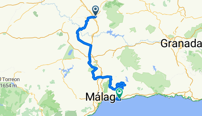
Lucena - Rincón de la Victoria
A cycling route starting in Lucena, Andalusia, Spain.
Overview
About this route
Third stage in line of the Vuelta Andalucia 2013
- -:--
- Duration
- 180.2 km
- Distance
- 2,373 m
- Ascent
- 2,794 m
- Descent
- ---
- Avg. speed
- ---
- Max. altitude
Route quality
Waytypes & surfaces along the route
Waytypes
Road
100.9 km
(56 %)
Track
21.6 km
(12 %)
Surfaces
Paved
55.9 km
(31 %)
Asphalt
55.9 km
(31 %)
Undefined
124.4 km
(69 %)
Continue with Bikemap
Use, edit, or download this cycling route
You would like to ride Lucena - Rincón de la Victoria or customize it for your own trip? Here is what you can do with this Bikemap route:
Free features
- Save this route as favorite or in collections
- Copy & plan your own version of this route
- Split it into stages to create a multi-day tour
- Sync your route with Garmin or Wahoo
Premium features
Free trial for 3 days, or one-time payment. More about Bikemap Premium.
- Navigate this route on iOS & Android
- Export a GPX / KML file of this route
- Create your custom printout (try it for free)
- Download this route for offline navigation
Discover more Premium features.
Get Bikemap PremiumFrom our community
Other popular routes starting in Lucena
 Circular Lucena - Carcabuey - Lucena IBP 93
- Distance
- 53.7 km
- Ascent
- 1,143 m
- Descent
- 1,141 m
- Location
- Lucena, Andalusia, Spain
 cabra, lucena virgen de la sierra
- Distance
- 97.2 km
- Ascent
- 1,432 m
- Descent
- 1,444 m
- Location
- Lucena, Andalusia, Spain
 Ruta BTT Encina Milenaria ( desde Lucena)
- Distance
- 8.3 km
- Ascent
- 175 m
- Descent
- 88 m
- Location
- Lucena, Andalusia, Spain
 Lucena-Baena
- Distance
- 45 km
- Ascent
- 300 m
- Descent
- 371 m
- Location
- Lucena, Andalusia, Spain
 Ruta BTT Puente Povedano (Lucena)
- Distance
- 8.9 km
- Ascent
- 278 m
- Descent
- 279 m
- Location
- Lucena, Andalusia, Spain
 Lucena - Antequera (Estación FC)
- Distance
- 55 km
- Ascent
- 442 m
- Descent
- 457 m
- Location
- Lucena, Andalusia, Spain
 Ruta BTT de la Encina Milenaria (desde Los Llanos de San Juan)
- Distance
- 6.8 km
- Ascent
- 295 m
- Descent
- 285 m
- Location
- Lucena, Andalusia, Spain
 Circuito Entrevias verdes
- Distance
- 316.9 km
- Ascent
- 1,914 m
- Descent
- 1,911 m
- Location
- Lucena, Andalusia, Spain
Open it in the app