Larochette-Senningerberg-Larochette
A cycling route starting in Larochette, District de Luxembourg, Luxembourg.
Overview
About this route
Leichte Strecke mit kontinuierlichem Anstieg bis Waldhof.
- -:--
- Duration
- 46.4 km
- Distance
- 318 m
- Ascent
- 318 m
- Descent
- ---
- Avg. speed
- ---
- Avg. speed
Route quality
Waytypes & surfaces along the route
Waytypes
Busy road
38 km
(82 %)
Path
6.8 km
(15 %)
Surfaces
Paved
46.2 km
(100 %)
Unpaved
0.2 km
(<1 %)
Asphalt
46.2 km
(100 %)
Unpaved (undefined)
0.2 km
(<1 %)
Undefined
0 km
(<1 %)
Continue with Bikemap
Use, edit, or download this cycling route
You would like to ride Larochette-Senningerberg-Larochette or customize it for your own trip? Here is what you can do with this Bikemap route:
Free features
- Save this route as favorite or in collections
- Copy & plan your own version of this route
- Sync your route with Garmin or Wahoo
Premium features
Free trial for 3 days, or one-time payment. More about Bikemap Premium.
- Navigate this route on iOS & Android
- Export a GPX / KML file of this route
- Create your custom printout (try it for free)
- Download this route for offline navigation
Discover more Premium features.
Get Bikemap PremiumFrom our community
Other popular routes starting in Larochette
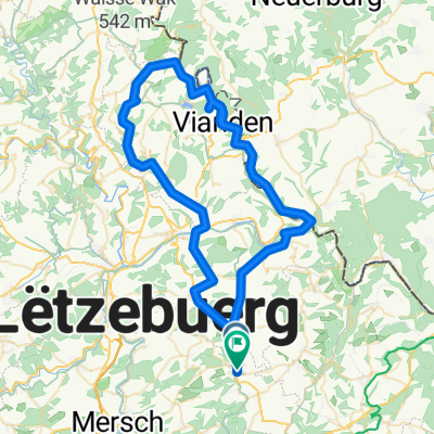
- Larochette-Weiler-Vianden-Larochette
- Distance
- 70.3 km
- Ascent
- 665 m
- Descent
- 661 m
- Location
- Larochette, District de Luxembourg, Luxembourg
- Müllerthal light
- Distance
- 49.8 km
- Ascent
- 413 m
- Descent
- 413 m
- Location
- Larochette, District de Luxembourg, Luxembourg
- Larochette - Larochette via Echternach
- Distance
- 51.8 km
- Ascent
- 347 m
- Descent
- 347 m
- Location
- Larochette, District de Luxembourg, Luxembourg
- Larochette-Senningerberg-Larochette
- Distance
- 46.4 km
- Ascent
- 318 m
- Descent
- 318 m
- Location
- Larochette, District de Luxembourg, Luxembourg
- Chemin J-A Zinnen 29, Larochette to Chemin J-A Zinnen 29, Larochette
- Distance
- 11.6 km
- Ascent
- 268 m
- Descent
- 268 m
- Location
- Larochette, District de Luxembourg, Luxembourg
- Larochette-Bettel-Bollendorf-Christnach-Larochette
- Distance
- 55.7 km
- Ascent
- 481 m
- Descent
- 481 m
- Location
- Larochette, District de Luxembourg, Luxembourg
- Larochette-Reuland- Koedange-Fischbach-Larochette
- Distance
- 24.6 km
- Ascent
- 379 m
- Descent
- 376 m
- Location
- Larochette, District de Luxembourg, Luxembourg
- Tourentipp Larochette
- Distance
- 8.1 km
- Ascent
- 201 m
- Descent
- 202 m
- Location
- Larochette, District de Luxembourg, Luxembourg
Open it in the app