

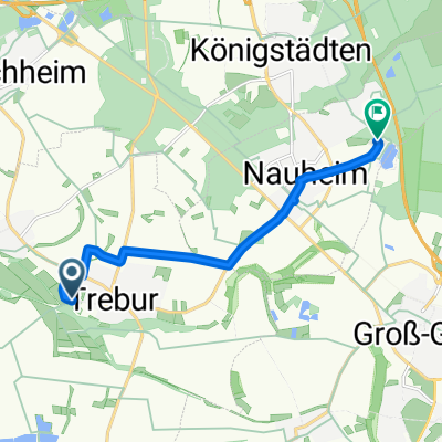
Flughafenrunde ab Trebur
A cycling route starting in Trebur, Hesse, Germany.
Overview
About this route
None (cloned from route 876380)
- -:--
- Duration
- 58.4 km
- Distance
- 104 m
- Ascent
- 106 m
- Descent
- ---
- Avg. speed
- ---
- Max. altitude
Continue with Bikemap
Use, edit, or download this cycling route
You would like to ride Flughafenrunde ab Trebur or customize it for your own trip? Here is what you can do with this Bikemap route:
Free features
- Save this route as favorite or in collections
- Copy & plan your own version of this route
- Sync your route with Garmin or Wahoo
Premium features
Free trial for 3 days, or one-time payment. More about Bikemap Premium.
- Navigate this route on iOS & Android
- Export a GPX / KML file of this route
- Create your custom printout (try it for free)
- Download this route for offline navigation
Discover more Premium features.
Get Bikemap PremiumFrom our community
Other popular routes starting in Trebur
 Beethovenstraße 9, Trebur nach Beethovenstraße 11, Trebur
- Distance
- 16.4 km
- Ascent
- 342 m
- Descent
- 341 m
- Location
- Trebur, Hesse, Germany
 Lutherlauf Trebur nach Nauheim
- Distance
- 8 km
- Ascent
- 15 m
- Descent
- 6 m
- Location
- Trebur, Hesse, Germany
 Rheinrundtour-2021
- Distance
- 40.5 km
- Ascent
- 30 m
- Descent
- 31 m
- Location
- Trebur, Hesse, Germany
 Trebur nach Langenau
- Distance
- 6.7 km
- Ascent
- 8 m
- Descent
- 11 m
- Location
- Trebur, Hesse, Germany
 Astheim - GG - Astheim
- Distance
- 34.4 km
- Ascent
- 31 m
- Descent
- 31 m
- Location
- Trebur, Hesse, Germany
 Mainspitze
- Distance
- 14.6 km
- Ascent
- 11 m
- Descent
- 12 m
- Location
- Trebur, Hesse, Germany
 Tour G. Reith
- Distance
- 6.1 km
- Ascent
- 4 m
- Descent
- 4 m
- Location
- Trebur, Hesse, Germany
 Astheim-Kühkopf-Astheim
- Distance
- 47.3 km
- Ascent
- 23 m
- Descent
- 23 m
- Location
- Trebur, Hesse, Germany
Open it in the app