

Misa
A cycling route starting in Senigallia, The Marches, Italy.
Overview
About this route
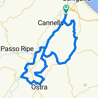
From Senigallia to Pianello on the PercorriMisa. From Pianello to Senigallia on the herons' path. Return to Fano on the Adriatic cycle path. 15 km of single track in the riverbed.
- -:--
- Duration
- 56.6 km
- Distance
- 69 m
- Ascent
- 72 m
- Descent
- ---
- Avg. speed
- ---
- Max. altitude
Continue with Bikemap
Use, edit, or download this cycling route
You would like to ride Misa or customize it for your own trip? Here is what you can do with this Bikemap route:
Free features
- Save this route as favorite or in collections
- Copy & plan your own version of this route
- Sync your route with Garmin or Wahoo
Premium features
Free trial for 3 days, or one-time payment. More about Bikemap Premium.
- Navigate this route on iOS & Android
- Export a GPX / KML file of this route
- Create your custom printout (try it for free)
- Download this route for offline navigation
Discover more Premium features.
Get Bikemap PremiumFrom our community
Other popular routes starting in Senigallia
 Senigallia monte Carotto
- Distance
- 84.7 km
- Ascent
- 541 m
- Descent
- 541 m
- Location
- Senigallia, The Marches, Italy
 senigallia - montefano
- Distance
- 56.6 km
- Ascent
- 474 m
- Descent
- 273 m
- Location
- Senigallia, The Marches, Italy
 Borgo Bicchia-Vaccarile
- Distance
- 38.2 km
- Ascent
- 162 m
- Descent
- 160 m
- Location
- Senigallia, The Marches, Italy
 per il caglio
- Distance
- 36.6 km
- Ascent
- 423 m
- Descent
- 420 m
- Location
- Senigallia, The Marches, Italy
 Misa
Misa- Distance
- 56.6 km
- Ascent
- 69 m
- Descent
- 72 m
- Location
- Senigallia, The Marches, Italy
 Senigallia Corinaldo Senigallia
- Distance
- 84 km
- Ascent
- 552 m
- Descent
- 552 m
- Location
- Senigallia, The Marches, Italy
 Lungo il Misa
- Distance
- 10.7 km
- Ascent
- 23 m
- Descent
- 0 m
- Location
- Senigallia, The Marches, Italy
 SENIGALLIa
- Distance
- 39.2 km
- Ascent
- 250 m
- Descent
- 250 m
- Location
- Senigallia, The Marches, Italy
Open it in the app