

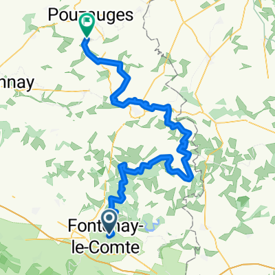
Fontenay-le-Comte > La Tranche sur Mer 2012
A cycling route starting in Fontenay-le-Comte, Pays de la Loire Region, France.
Overview
About this route
Fontenay-le-Comte > La Tranche sur Mer 2012
- -:--
- Duration
- 90.5 km
- Distance
- 112 m
- Ascent
- 117 m
- Descent
- ---
- Avg. speed
- ---
- Max. altitude
Route quality
Waytypes & surfaces along the route
Waytypes
Road
43.4 km
(48 %)
Quiet road
5.4 km
(6 %)
Surfaces
Paved
10.9 km
(12 %)
Asphalt
10.9 km
(12 %)
Undefined
79.7 km
(88 %)
Continue with Bikemap
Use, edit, or download this cycling route
You would like to ride Fontenay-le-Comte > La Tranche sur Mer 2012 or customize it for your own trip? Here is what you can do with this Bikemap route:
Free features
- Save this route as favorite or in collections
- Copy & plan your own version of this route
- Split it into stages to create a multi-day tour
- Sync your route with Garmin or Wahoo
Premium features
Free trial for 3 days, or one-time payment. More about Bikemap Premium.
- Navigate this route on iOS & Android
- Export a GPX / KML file of this route
- Create your custom printout (try it for free)
- Download this route for offline navigation
Discover more Premium features.
Get Bikemap PremiumFrom our community
Other popular routes starting in Fontenay-le-Comte
 Recording from 27 Apr 2017, 17.43
- Distance
- 133 km
- Ascent
- 165 m
- Descent
- 176 m
- Location
- Fontenay-le-Comte, Pays de la Loire Region, France
 Fontenay-le-Comte > La Tranche sur Mer 2012
- Distance
- 90.5 km
- Ascent
- 112 m
- Descent
- 117 m
- Location
- Fontenay-le-Comte, Pays de la Loire Region, France
 Fontenay forest loop
- Distance
- 26.3 km
- Ascent
- 284 m
- Descent
- 248 m
- Location
- Fontenay-le-Comte, Pays de la Loire Region, France
 De Allée de la Vallée Verte à D105E1
- Distance
- 42.5 km
- Ascent
- 82 m
- Descent
- 141 m
- Location
- Fontenay-le-Comte, Pays de la Loire Region, France
 TDF 5. Etappe Fontenay-le-Comte - Perigueux
- Distance
- 234.8 km
- Ascent
- 953 m
- Descent
- 865 m
- Location
- Fontenay-le-Comte, Pays de la Loire Region, France
 Fontenay-le-Comte - La Meilleraie-Tillay
- Distance
- 86.4 km
- Ascent
- 1,006 m
- Descent
- 893 m
- Location
- Fontenay-le-Comte, Pays de la Loire Region, France
 France2023 E28
- Distance
- 71 km
- Ascent
- 923 m
- Descent
- 827 m
- Location
- Fontenay-le-Comte, Pays de la Loire Region, France
 2009 3.Etappe Tour Vire - Sanse
- Distance
- 108.3 km
- Ascent
- 454 m
- Descent
- 419 m
- Location
- Fontenay-le-Comte, Pays de la Loire Region, France
Open it in the app