

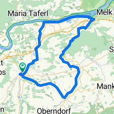
Wildpark Hochrieß
A cycling route starting in Petzenkirchen, Lower Austria, Austria.
Overview
About this route
Gemütliche Runde für kurze Ausfahrt.
- -:--
- Duration
- 7.5 km
- Distance
- 59 m
- Ascent
- 20 m
- Descent
- ---
- Avg. speed
- ---
- Max. altitude

Route quality
Waytypes & surfaces along the route
Waytypes
Road
4.1 km
(55 %)
Quiet road
2.7 km
(35 %)
Surfaces
Paved
7.2 km
(96 %)
Asphalt
7.2 km
(96 %)
Undefined
0.3 km
(4 %)
Continue with Bikemap
Use, edit, or download this cycling route
You would like to ride Wildpark Hochrieß or customize it for your own trip? Here is what you can do with this Bikemap route:
Free features
- Save this route as favorite or in collections
- Copy & plan your own version of this route
- Sync your route with Garmin or Wahoo
Premium features
Free trial for 3 days, or one-time payment. More about Bikemap Premium.
- Navigate this route on iOS & Android
- Export a GPX / KML file of this route
- Create your custom printout (try it for free)
- Download this route for offline navigation
Discover more Premium features.
Get Bikemap PremiumFrom our community
Other popular routes starting in Petzenkirchen
 W-Diesendorf-Melk(Kraftwerk)-pöchlarn-w
- Distance
- 53.2 km
- Ascent
- 213 m
- Descent
- 212 m
- Location
- Petzenkirchen, Lower Austria, Austria
 Wieselburg Großa Hochriess Purgstall Runde
- Distance
- 20.5 km
- Ascent
- 228 m
- Descent
- 228 m
- Location
- Petzenkirchen, Lower Austria, Austria
 Annatsberg - Frankenfels - Annatsberg
- Distance
- 77.1 km
- Ascent
- 809 m
- Descent
- 809 m
- Location
- Petzenkirchen, Lower Austria, Austria
 Wildpark Hochrieß
- Distance
- 7.5 km
- Ascent
- 59 m
- Descent
- 20 m
- Location
- Petzenkirchen, Lower Austria, Austria
 Texingtal
- Distance
- 65 km
- Ascent
- 513 m
- Descent
- 512 m
- Location
- Petzenkirchen, Lower Austria, Austria
 Wieselburg - Wastl - Erlaufboden - Wieselburg
- Distance
- 104.3 km
- Ascent
- 1,460 m
- Descent
- 1,461 m
- Location
- Petzenkirchen, Lower Austria, Austria
 Kendl - Rainberg - Brunnwiesen - Petzenkirchen - Kendl
- Distance
- 15.8 km
- Ascent
- 182 m
- Descent
- 187 m
- Location
- Petzenkirchen, Lower Austria, Austria
 Schöllenbach - Plankenstein - Luft - Pöchlarn - Sarling
- Distance
- 93.7 km
- Ascent
- 1,642 m
- Descent
- 1,657 m
- Location
- Petzenkirchen, Lower Austria, Austria
Open it in the app