

Tigard to Wilsonville
A cycling route starting in Durham, Oregon, United States.
Overview
About this route
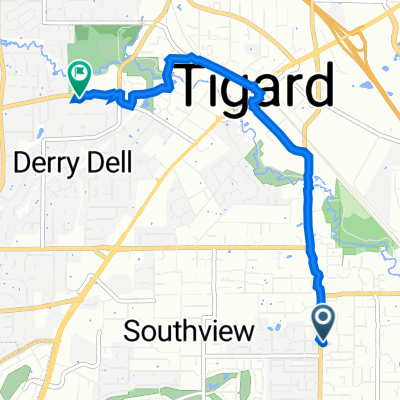
near SW Durham Rd & SW Upper Boones Ferry Rd, Portland, OR 97224
via SW 95th Ave Remove
via SW 95th Ave Remove
Depart OR-141 / SW Upper Boones Ferry Rd toward SW Afton Ln,4.9 mi
Turn right onto SW 95th Ave Pass Holiday Inn in 0.4 mi, 1.5 mi
Turn left onto SW Boeckman Rd, 0.4 mi
Turn left onto SW Parkway Ave, 0.2 mi
Arrive at near 27493 SW Parkway Ave, Wilsonville, OR 97070
The last intersection is SW Boeckman Rd
If you reach Xerox Dr, you've gone too far
near 27493 SW Parkway Ave, Wilsonville, OR 97070
- -:--
- Duration
- 11.7 km
- Distance
- 134 m
- Ascent
- 110 m
- Descent
- ---
- Avg. speed
- ---
- Max. altitude

Route quality
Waytypes & surfaces along the route
Waytypes
Quiet road
1.2 km
(10 %)
Road
1.1 km
(9 %)
Surfaces
Paved
4.9 km
(42 %)
Asphalt
4.6 km
(39 %)
Paved (undefined)
0.4 km
(3 %)
Undefined
6.8 km
(58 %)
Continue with Bikemap
Use, edit, or download this cycling route
You would like to ride Tigard to Wilsonville or customize it for your own trip? Here is what you can do with this Bikemap route:
Free features
- Save this route as favorite or in collections
- Copy & plan your own version of this route
- Sync your route with Garmin or Wahoo
Premium features
Free trial for 3 days, or one-time payment. More about Bikemap Premium.
- Navigate this route on iOS & Android
- Export a GPX / KML file of this route
- Create your custom printout (try it for free)
- Download this route for offline navigation
Discover more Premium features.
Get Bikemap PremiumFrom our community
Other popular routes starting in Durham
 15000 SW Hall Blvd, Tigard to 11100 SW Walnut St, Tigard
- Distance
- 4.8 km
- Ascent
- 250 m
- Descent
- 185 m
- Location
- Durham, Oregon, United States
 LaGo to Wilsonville, OR
- Distance
- 12.8 km
- Ascent
- 114 m
- Descent
- 118 m
- Location
- Durham, Oregon, United States
 LO to West Linn
- Distance
- 55.5 km
- Ascent
- 685 m
- Descent
- 721 m
- Location
- Durham, Oregon, United States
 Supersonic route in Lake Oswego
- Distance
- 26.7 km
- Ascent
- 92 m
- Descent
- 156 m
- Location
- Durham, Oregon, United States
 Inza R wood Middle school
- Distance
- 18 km
- Ascent
- 140 m
- Descent
- 130 m
- Location
- Durham, Oregon, United States
 Tigard to Wilsonville
- Distance
- 11.7 km
- Ascent
- 134 m
- Descent
- 110 m
- Location
- Durham, Oregon, United States
 Home-THS-Cook Park-Tualatin-Home
- Distance
- 22.5 km
- Ascent
- 89 m
- Descent
- 91 m
- Location
- Durham, Oregon, United States
 fanno creek from Bonita
- Distance
- 18.4 km
- Ascent
- 120 m
- Descent
- 120 m
- Location
- Durham, Oregon, United States
Open it in the app