- 22 km
- 142 m
- 211 m
- Bad Reichenhall, Bavaria, Germany
Höglrunde normal 10.07.2013
A cycling route starting in Bad Reichenhall, Bavaria, Germany.
Overview
About this route
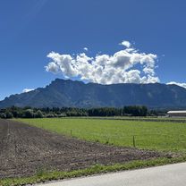
A very demanding route with many climbs, but a beautiful view of the mountains. At the beginning rather flat, but from Piding it gets really steep uphill all the way to the Högl mast, the last part from Strobl Alm to the mast is flat, just the last meters a short climb. The descent from the mast to Anger is not safe, brakes should be functional, with many unpredictable curves. The further route is rather rolling until Thundorf, then the last big climb to Kohlstatt and then a dangerous and fast descent to Ainring. The last kilometers are rather flat until Bad Reichenhall, well suited for easing off.
- -:--
- Duration
- 55.1 km
- Distance
- 657 m
- Ascent
- 656 m
- Descent
- ---
- Avg. speed
- ---
- Max. altitude
created this 12 years ago
Route quality
Waytypes & surfaces along the route
Waytypes
Quiet road
30.3 km
(55 %)
Road
13.2 km
(24 %)
Surfaces
Paved
50.7 km
(92 %)
Asphalt
50.7 km
(92 %)
Undefined
4.4 km
(8 %)
Continue with Bikemap
Use, edit, or download this cycling route
You would like to ride Höglrunde normal 10.07.2013 or customize it for your own trip? Here is what you can do with this Bikemap route:
Free features
- Save this route as favorite or in collections
- Copy & plan your own version of this route
- Sync your route with Garmin or Wahoo
Premium features
Free trial for 3 days, or one-time payment. More about Bikemap Premium.
- Navigate this route on iOS & Android
- Export a GPX / KML file of this route
- Create your custom printout (try it for free)
- Download this route for offline navigation
Discover more Premium features.
Get Bikemap PremiumFrom our community
Other popular routes starting in Bad Reichenhall
- Baderstraße, Bad Reichenhall nach Europastraße, Salzburg
- Höglrunde normal 10.07.2013
- 55.1 km
- 657 m
- 656 m
- Bad Reichenhall, Bavaria, Germany
- Reichenhall Runde
- 63.9 km
- 1,149 m
- 1,153 m
- Bad Reichenhall, Bavaria, Germany
- Baderstraße, Bad Reichenhall nach Europastraße, Salzburg
- 18.4 km
- 138 m
- 208 m
- Bad Reichenhall, Bavaria, Germany
- Baderstraße, Bad Reichenhall nach Europastraße, Salzburg
- 17.2 km
- 83 m
- 151 m
- Bad Reichenhall, Bavaria, Germany
- 🚵♂️Hintersee⛰️Litzlalm⛰️⛰️Unken🍂🍁Runde
- 60.9 km
- 1,052 m
- 1,018 m
- Bad Reichenhall, Bavaria, Germany
- Tivolistraße, Bad Reichenhall nach Europastraße, Salzburg
- 18.7 km
- 178 m
- 230 m
- Bad Reichenhall, Bavaria, Germany
- Baderstraße, Bad Reichenhall nach Europastraße, Salzburg
- 18.8 km
- 84 m
- 152 m
- Bad Reichenhall, Bavaria, Germany
Open it in the app


